Hurricane Matthew reorganizing over the Bahamas; major shift in long-range track
 By: Jeff Masters , From Weather Underground
Hurricane Matthew was a weakened a Category 3 hurricane with 115 mph winds on Wednesday morning at 8 am EDT, thanks to the disruptions to the storm caused by landfalls in Haiti and Cuba on Tuesday. However, the storm is re-organizing over the warm waters of The Bahamas, and poses a serious threat to The Bahamas and Southeast U.S. over the next three days. Matthew’s top winds had rebounded slightly, to 120 mph, as of the 11 am advisory from the National Hurricane Center.
Matthew was able to shrug off its initial landfall on the southwestern tip of Haiti near 7 am EDT Tuesday, with the hurricane’s Category 4 winds of 145 mph dropping by just 5 mph. A more protracted landfall over the eastern tip of Cuba on Tuesday evening, though, disrupted the storm’s eyewall, which suffered a partial collapse. As a result of this, plus the fact that a large part of the storm’s circulation has been over the high
mountains of Cuba and Hispaniola over the past day, Matthew was looking considerably less impressive on satellite imagery on Wednesday morning. The hurricane’s heavy thunderstorms were much reduced in the northwest quadrant, and Matthew was smaller and had fewer low-level spiral bands.
Figure 1. Enhanced infrared image of Matthew as of 10:00 am EDT Wednesday, October 5, 2016. Matthew’s eye had sharpened distinctly over the preceding few hours. Image credit: NASA/MSFC Earth Science Office.
Two hurricane hunter aircraft were in Matthew early on Wednesday morning, and confirmed Matthew had weakened significantly; the top surface winds of the hurricane had slowed to 115 mph and the central pressure had risen to 964 mb. A rapid-scan 1-minute time resolution satellite loop of Matthew from NASA/MSFC late Wednesday morning showed that Matthew was steadily re-organizing, though. The hurricane has rebuilt its eyewall, spiral bands were increasing in intensity and areal coverage, and Matthew was growing larger. This is to be expected, as Matthew has favorable conditions for intensification: light to moderate wind shear of 5 – 15 knots, very warm ocean waters of 29.5 – 30°C (85 – 86°F) and 70 – 75% relative humidity at mid-levels of the atmosphere (as analyzed by the SHIPS model.) In their most recent pass through the eye late Wednesday morning, the Hurricane Hunters found the pressure had dropped 2 mb, to 962 mb, and the winds had increased by 5 mph.
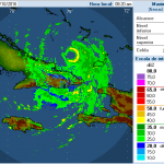
Figure 2. Hurricane Matthew as seen on Gran Piedra, Cuba radar at 8:20 am EDT October 5, 2016. A mostly complete eyewall had been rebuilt by this time. Image credit: INSMET.
Intensity forecast: Matthew will be big and bad again
Given the favorable conditions for intensification, and the fact that Matthew is now moving into a region with even warmer waters (though a lessening amount of total ocean heat content), I expect the storm will again be at Category 4 strength by Thursday morning. The near-record warm waters Matthew will be feeding from will allow the hurricane to greatly expand its size over the next two days, as will the fact that it will be steadily gaining latitude, allowing the hurricane to better leverage the Earth’s spin to gain more spin of its own. The unusual mass of convection to the east that persisted until it made landfall in Hispaniola has apparently been absorbed, and will also contribute to Matthew expanding in size. This is going to be a very large storm with widespread impacts by the time it approaches the Southeast U.S. on Thursday evening, and Matthew is likely to be a major Category 3 or stronger hurricane while it pounds the northern Bahamas and east coast of Florida. Matthew may take an extended path over the core of the very warm Gulf Stream current on Friday, providing an extra boost in intensity.
On Friday night, when Matthew will be moving northwards nearly parallel to the coast and approaching South Carolina, high wind shear of 20+ knots is expected to attack the storm. High wind shear plus potential interaction with land will likely lead to a weakening of Matthew to Category 2 strength by Saturday, when the hurricane will make its closest approach to South Carolina and North Carolina. As Matthew makes its expected turn to the east on Sunday and moves parallel to the North Carolina coast, wind shear will rise even further, to 40+ knots, and we can expect Matthew to weaken to a Category 1 hurricane or tropical storm by Monday of next week.
Track forecast for Matthew: very bad for the Bahamas
Matthew will move northwest through The Bahamas on Wednesday and Thursday, with the dangerous right front quadrant with the highest winds likely to affect the most populous island in the archipelago, New Providence, on Thursday morning. Extreme winds are the main danger on New Providence, though a storm surge of up to ten feet is possible. Fortunately, the capital of Nassau is on the more protected north side of the island, which is less vulnerable to storm surge. Low tide in Nassau is at 5:22 am EDT Thursday, and high tide is at 11:46 am EDT. Tidal range between low tide and high tide is about two feet, so the timing of the high tide relative to a possible ten-foot storm surge can contribute up to a 20% increase in the observed storm tide (the height of the water above ground.) In their 11 am EDT Wednesday Wind Probability Forecast, NHC gave highest odds of hurricane-force winds in The Bahamas to Great Exuma (78%), New Providence (74%), and Grand Bahama (64%).
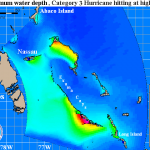
Figure 3. This Maximum Water Depth storm surge image for The Bahamas shows the worst-case inundation scenario for a Category 3 hurricane with 120 mph winds, as predicted using dozens of runs of NOAA’s SLOSH model. For example, if you are inland at an elevation of ten feet, and the combined storm surge and tide (the “storm tide”) is fifteen feet at your location, the water depth image will show five feet of inundation.
Major storm-surge potential for The Bahamas
No single storm will be able to cause the level of flooding depicted everywhere in Figure 3 above, but Matthew’s maximum storm surge may reach levels portrayed in this image for some of these islands. The greatest surge danger for Exuma Island and Long Island will come on Wednesday evening shortly after Matthew passes. Large expanses of shallow water lie along the west coasts of these islands, and the counter-clockwise circulation of the storm will push water to the east and northeast into these shallow water, where they will be forced up onto land. New Providence (where the capital of Nassau is located) has its shallowest waters to the south, so their main storm surge risk will come as Matthew is approaching from the southeast. According to a Tuesday blog post by storm surge expert Dr. Hal Needham, “Many areas in this archipelago contain broad reefs that provide large pools of shallow water for hurricanes to displace and inflict storm surge damage. The impacts of these surges are often severe, sea water can overwash small islands, completely inundating them with salt. Such surges often destroy fresh water and food supplies, as saline soils can take years to lose high salt content. Of particular concern is the possibility that Matthew will track far enough east to produce a large storm surge on Crooked Island, Acklins Island and Long Cay. Hurricane Joaquin generated a devastating 15-ft (4.57-m) storm surge in this area just last October, taking advantage of a shallow reef that is open to the southwest. A second large storm surge in two years would have grave impacts for this region.” Note that the elevations of the surge heights on this map is not Mean Sea Level (MSL), but rather the vertical datum, NGVD 1929, developed by the National Geodetic Survey. See wunderground’s storm surge pages for more info.
Track forecast for Matthew: Hurricane Warnings and Storm Surge Warnings for Florida
The 00Z Wednesday runs of our top models for forecasting hurricane tracks—the GFS, European, and UKMET models—all show that Matthew will approach within 50 miles of, or make landfall on, the coast of Central Florida on Friday. The 06Z Wednesday run of the GFS model showed this, as well. At 11 am EDT Wednesday, Hurricane Warnings were up for much of the east coast of Florida, including the Orlando area, and NHC had issued a new experimental Storm Surge Warning for the coast of Florida from North Palm Beach to the Flagler/Volusia County line. A storm surge warning indicates there is a danger of life-threatening inundation from rising water moving inland from the shoreline somewhere within the specified area, generally within 36 hours. NHC is advising that storm surge inundation of 3 – 5 feet could occur on Friday. Farther to the north of the warned area, extending to Fernandina Beach, a Storm Surge Watch is posted, meaning that there is the possibility of life-threatening inundation during the next 48 hours. The greater threat to Florida, though, may be wind damage. In their 11 am EDT Wednesday Wind Probability Forecast, NHC gave highest odds of hurricane-force winds in Florida to Ft. Pierce (47%), West Palm Beach (43%), and Cocoa Beach (40%).
Track forecast for Matthew: danger to North Carolina and New England lessens
Wednesday’s latest 00Z run of the European model and 06Z run of the GFS model predicted that Matthew would turn to the northeast and then east on Saturday, keeping the storm several hundred miles south of the coast of North Carolina. In this scenario, the coasts of Georgia and southern South Carolina might still be at risk of hurricane force winds, but the coast farther north—including New England and Canada—would not be. In their 11 am EDT Wednesday Wind Probability Forecast, NHC was giving the coast from Jacksonville, Florida to Charleston, South Carolina 10 – 16% chances of receiving hurricane force winds. Probabilities for the coast of North Carolina were less than 10%.
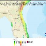
Figure 4. Screen shot of NHC’s interactive Storm Surge Probability product from 5 am EDT Wednesday, October 5, 2016, showing the probability of inundation in excess of 3’ above ground level from Matthew. The northern Florida coast to the coast of South Carolina is expected to have a greater than 50% chance of getting inundation in excess of three feet. The highest probabilities are along the Georgia coast, where hurricane impacts are fairly infrequent. The graphic is based upon an ensemble of Sea, Lake, and Overland Surges from Hurricanes (SLOSH) model runs created using the current National Hurricane Center (NHC) official hurricane advisory. Storm surge probabilities depend on the historical accuracy of NHC’s forecasts of hurricane track, and wind speed, and an estimate of storm size.
Long range forecast for Matthew: thrown for a loop
Thanks to my advancing years and a low-stress lifestyle that features daily meditation, there’s not much that can move me to profanity—except the occasional low-skill driver who endangers my life on the road. But this morning while looking at the latest weather model runs, multiple very bad words escaped my lips. I’ve been a meteorologist for 35 years, and am not easily startled by a fresh set of model results: situations in 2005 and 1992 are the only ones that come to mind. However, this morning’s depiction by our top models—the GFS, European, and UKMET—of Matthew missing getting picked up by the trough to its north this weekend and looping back to potentially punish The Bahamas and Florida next week was worthy of profuse profanity. While a loop back towards Florida and The Bahamas next week is not yet a sure thing, the increasing trend of our top models in that direction is a strong indication that Matthew will be around for a very long time. Long-range forecasts of wind shear are not very reliable, but this morning’s wind shear forecast from the 00Z run of the European model does show a low to moderate shear environment over the Bahamas and waters surrounding South Florida late next week, potentially supportive of a hurricane–if Matthew survives the high wind shear of 50+ knots expected to affect the storm early next week. The bottom line is that it currently appears that Matthew will not recurve out to sea early next week, and The Bahamas and Florida may have to deal with the storm again next week.
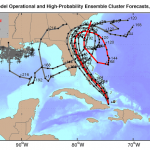
Figure 5. Track forecasts from the five European model ensemble members [gray lines] that most closely match the operational run [red line] during the first 72 hours, starting at 00Z Wednesday, October 5, 2016. The red line is a version of the 00Z Wednesday operational model track that has been adjusted and calibrated using a proprietary technique to account for systemic model errors. Five out of six of these forecasts show Matthew barely missing landfall along the Southeast U.S. coast, and all of them show Matthew failing to recurve out to sea to the northeast. Disturbingly, two of the tracks show Matthew looping back to punish The Bahamas and crossing South Florida to enter the Gulf of Mexico. The high-probability cluster (grey lines) perform better than other ensemble members at forecast times of five days and beyond. The black crosses along the Gulf Coast are the locations of oil wells, as this forecast tool was designed primarily for use by the oil and gas industry. Image credit: Climate Forecast Applications Network (CFAN).
For more on this story go to: https://www.wunderground.com/blog/JeffMasters/comment.html?entrynum=3464


