Tropical Storm Zeta forms near Grand Cayman


Tropical Storm Zeta Discussion Number 3
NWS National Hurricane Center Miami FL
500 AM EDT Sun Oct 25 2020
Earlier this morning, the tropical cyclone located over the
northwestern Caribbean Sea was upgraded to Tropical Storm Zeta at
0600 UTC based on 0314Z ASCAT surface wind data of 32-33 kt
located southeast of the broad center. Since then, a NOAA
reconnaissance aircraft has been investigating Zeta and has found
maximum 925-mb flight-level winds of about 40 kt and reliable SFMR
surface winds of 33-36 kt. Recent satellite classifications from
TAFB, SAB, and UW-CIMSS are 35 kt. Based on these data, the initial
intensity is set at 35 kt.
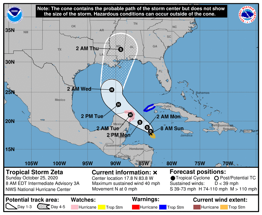
The initial motion estimate is stationary. Although Zeta has been
steadily losing latitude during the past 12 hours, this has been
primarily due to the broad low-level center reforming closer to the
very intense convection located in the southern semicircle of the
cyclone’s large circulation. Satellite trends over the past 6 hours
indicate that a mid-level circulation located about 90 nmi east of
the low-level center is likely imparting a weak southerly component
of motion on Zeta as well. Over the course of the next 72 hours, a
weak shortwave trough currently located over the southeastern U.S.
from the Tennessee Valley southward into the north-central Gulf of
Mexico will continue to move eastward, allowing a low- to mid-level
ridge to steadily build westward across the Bahamas, Florida, and
the central Gulf of Mexico. This will gradually force Zeta on a
northwestward track across or near the northeastern tip of the
Yucatan Peninsula in about 48 h and into the central Gulf of Mexico
by 72 h. The latest NHC model guidance is in very agreement on this
developing 3-day track scenario. Thereafter, however, the models
diverge fairly significantly due to uncertainty in the evolution of
the next steering mechanism — a trough over the northwestern U.S.
that will dig southward and phase up/merge with a trough off the
southern California and Baja California coasts. Phasing of northern
and southern stream systems is always difficult to forecast,
especially when one of those systems is outside the U.S. upper-air
observing system like the system currently is off southern
California. After the two systems phase in about 48 hours, a
powerful mid/upper-level low is forecast to form by 72 h and eject
eastward out of the southwestern U.S., causing the ridge over the
Gulf of Mexico to erode eastward. This will allow Zeta to turn
northward and then northeastward toward the north-central Gulf
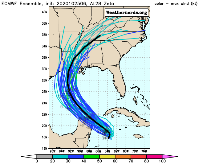
coast. The global models remain in poor agreement on the details
of the timing of the eastward movement of the upper-low, resulting
in model solutions ranging from Louisiana (ECMWF-UKMET-FSSE) to the
Florida Panhandle (HWRF-HMON). The new NHC track forecast is a
little left of the previous advisory track through 72 hours, and
lies near the middle of the guidance envelope, close to the HCCA and
TVCA multi-model consensus. However, given the current lack of
motion of the system and the large model spread late in the period,
the details of the track forecast are more uncertain than usual.
Although the low- and mid-level circulations remain unaligned, the
overall environment for the next 60-72 hours is expected to remain
conducive for at least gradual intensification. After 72 hours,
however, the deep-layer vertical wind shear is expected to increase
while Zeta moves over cooler SSTs near the northern Gulf Coast,
which should result in weakening before the cyclone moves inland.
The new NHC intensity forecast is a tad higher than the previous
advisory, and lies near the upper end of the intensity guidance.
While the current NHC forecast indicates that the system should
weaken below hurricane strength before landfall, users are reminded
that strong tropical storms can still produce significant storm
surge, rainfall, and wind impacts along the northern Gulf Coast. The
cyclone should be absorbed into a frontal system by the end of the
forecast period.
KEY MESSAGES:
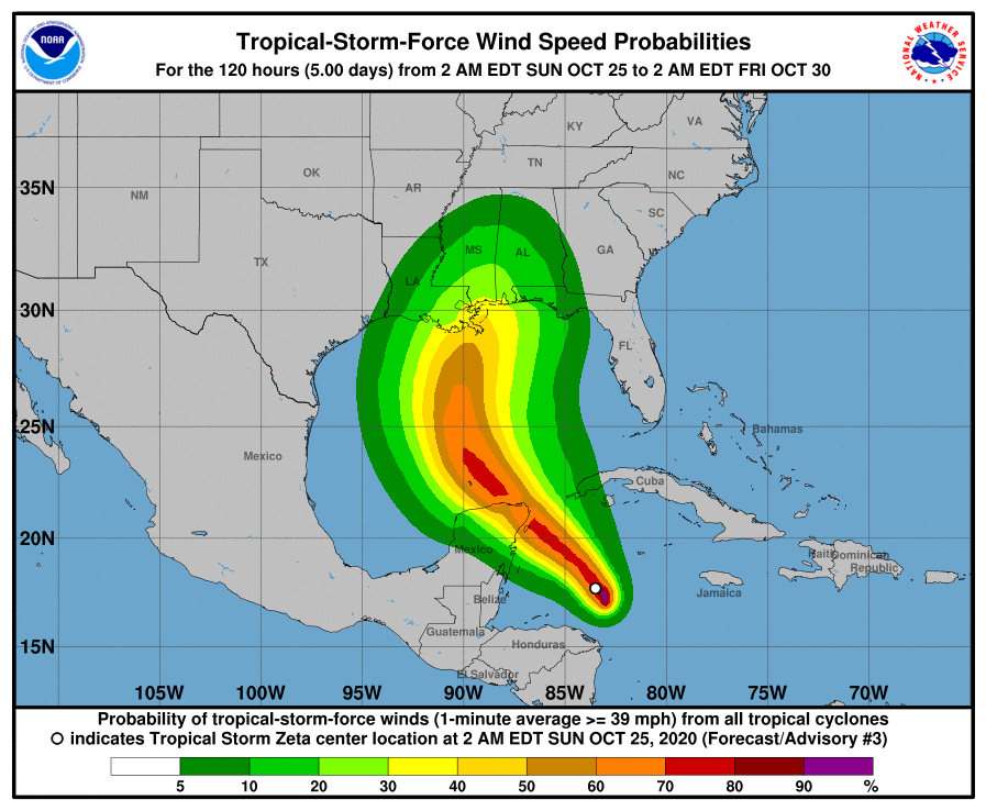
- Zeta is expected to produce tropical storm conditions over
extreme western Cuba on Monday. Tropical storm conditions are
possible in the northern Yucatan Peninsula of Mexico Monday night
and early Tuesday. - Through Wednesday, heavy rainfall is expected from Tropical Storm
Zeta across portions of central and western Cuba, the Cayman
Islands, Jamaica, the northeast Yucatan peninsula of Mexico,
Southern Florida and the Keys. This rainfall may lead to flash
flooding in urban areas. - Zeta is forecast to approach the northern Gulf Coast as a
tropical storm Tuesday night and Wednesday, and could bring storm
surge, rainfall, and wind impacts to areas from Louisiana to the
Florida Panhandle. Residents in these areas should monitor the
progress of Zeta and updates to the forecast.
FORECAST POSITIONS AND MAX WINDS
INIT 25/0900Z 17.7N 83.5W 35 KT 40 MPH
12H 25/1800Z 18.2N 83.8W 40 KT 45 MPH
24H 26/0600Z 18.9N 84.4W 45 KT 50 MPH
36H 26/1800Z 19.8N 85.7W 55 KT 65 MPH
48H 27/0600Z 21.1N 87.4W 65 KT 75 MPH
60H 27/1800Z 22.9N 89.5W 70 KT 80 MPH
72H 28/0600Z 25.4N 90.7W 65 KT 75 MPH
96H 29/0600Z 32.0N 89.1W 35 KT 40 MPH…INLAND
120H 30/0600Z…DISSIPATED
$$
Forecaster Stewart


