StormGeo: Atlantic Hurricane Season Forecast 2024 – 21 Named Storms,11 Hurricanes, 5 Intense Hurricanes

Atlantic Hurricane Season Forecast 2024
By Chris Hebert TropicsWatch Manager, Houston
The 2023 hurricane season ended with 20 named storms, including one unnamed subtropical storm that formed in January. There were 7 hurricanes, 3 of which became intense hurricanes. The Azores-Bermuda high pressure center was weaker and located farther east than normal, which allowed for most of the storms to turn northward before reaching the Caribbean Sea.
The primary land impact came from Hurricane Idalia, which formed near western Cuba in late August and struck northern Florida on August 30th as a Category 3 hurricane with max sustained wind near 115 mph. However, it is possible that Idalia was weaker at landfall, as there were no direct wind observations available.


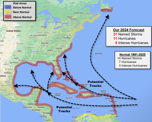
The Atlantic Hurricane Season Risk Map above shows risk areas for impact and the predicted number of storms.
A Return of La Nina?
In 2023, El Niño, a warming of the Tropical Pacific, dominated. Typically, when the Tropical Pacific is warmer than normal, hurricane activity increases there but is inhibited in the Atlantic Basin. However, El Niño did not have much of an impact on the Atlantic season last year. For 2024, all models are predicting that El Niño will quickly fade this spring and transition to La Niña, a cooling of the Tropical Pacific. A La Niña would tend to enhance activity in the Atlantic Basin.
Atlantic Water Temperatures – Very Warm
Water temperatures across the Tropical Atlantic from the Caribbean Sea to Africa are well above normal for this time of year. In fact, water temperatures are already close to what would be expected in June or July there. The warmer the water, the greater the potential for hurricanes to become stronger. This warm water could also allow for development east of the Caribbean earlier in the season than normal, as long as wind shear is low enough to allow for development there.
Analog Seasons
An analog season is a season in the past with a similar setup of ocean temperatures and atmospheric flow patterns to what we are seeing at present. The thinking is that if the current state of the tropics closely matches that of a year in the past, then seasonal activity this season could be somewhat similar to the activity in the analog season in terms of numbers and tracks. For the 2024 season, we have identified 7 analog seasons. Those seasons are 1995, 1998, 2010, 2011, 2016, 2021 and 2022. Together, these seasons averaged a total of 17 named storms with 9 hurricanes and 4 intense hurricanes. That’s well above the 30-year climatological average of 14 named storms, 7 hurricanes, and 3 intense hurricanes. Analog seasons indicate an increased risk to the islands of the northeast Caribbean, the western Caribbean, the Gulf of Mexico, and the East U.S. Coast. Basically, most areas appear to be at an above-normal risk of a hurricane impact this season.
European Model Forecast
The first season outlook from the European model was released on March 5th. That forecast is quite bullish on a busy hurricane season. Though only extending through the first four months of the season, the forecast is for 17.4 named storms and 8.7 hurricanes. The model does not distinguish between hurricanes and intense hurricanes. With two months left in the season after September, the European model is predicting a total of 20 or more named storms with possibly ten or more hurricanes. This is the greatest amount of activity that the European model has ever predicted. The European model is also predicting significantly enhanced rainfall across the Caribbean Sea and the Gulf of Mexico, a signal of increased hurricane activity there.
March Forecast
All signals point to a very active hurricane season. Unusually warm water across most of the Atlantic will combine with a developing La Niña to make for a favorable environment for development. The only remaining question is whether the Azores-Bermuda High will be stronger than last season, as some models are predicting. This high center acts as a steering mechanism for developing storms in the Main Development Region east of the Caribbean. For the past several seasons, that high has been relatively weak, allowing many of the hurricanes to turn northward before reaching the Caribbean Sea. A stronger high center would tend to steer developing storms farther west and into the Caribbean. This would pose an increasing risk of a hurricane landfall across all of the Caribbean, the Gulf of Mexico, and the southeast U.S. coast.
For 2024, we are predicting a total of 21 named storms with 11 hurricanes, including 5 intense hurricanes. Just about all areas will have an above-normal risk of a hurricane impact. In particular, the islands of the northeast Caribbean and the southeast U.S. may have a well above-normal risk of a hurricane impact. If wind shear across the Deep Tropics is not too high, then we could see early hurricane development east of the Caribbean Sea. Normally, the date of the first hurricane is in early August. This year, the first hurricane could form in June.
Download Atlantic Hurricane Season Outlook PDF >
For more on this story go to: STORMGEO


