Oscar makes landfall in the Bahamas after rapid intensification
From AccuWeather
AccuWeather Global Weather Center – Oct. 20, 2024 – Hurricane Oscar made landfall Sunday morning in the Inagua Islands of the Bahamas as a Category 1 hurricane after rapidly intensifying into a dangerous storm over the past 72 hours.
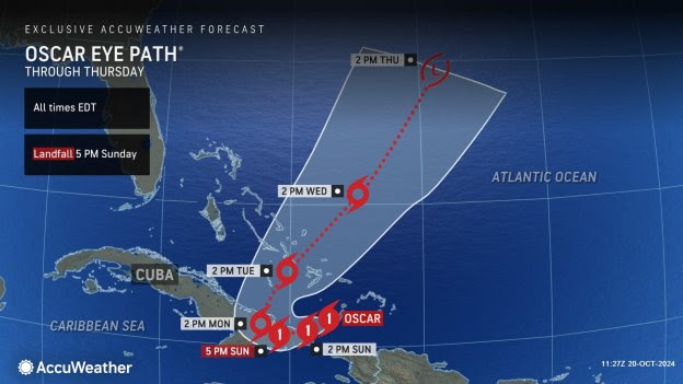
AccuWeather Chief Meteorologist Jon Porter says Oscar could have devastating impacts once it makes a second landfall in Cuba later today.
“Hurricane impacts to Cuba are extremely concerning because of the ongoing power grid crisis in Cuba. Adding a hurricane hit on top of the existing power failure can make the hurricane impact far worse, further risking lives and resulting in challenges in preparing for, responding to, and recovering from the hurricane’s impacts,” said AccuWeather Chief Meteorologist Jon Porter. “Heavy rain falling in the steep terrain of southeastern Cuba raises serious concerns about major flash flooding, as well as mudslides and rockslides. Unfortunately, the combination of these factors may result in a humanitarian crisis in some parts of southeast Cuba should a more intense Oscar make a close pass or even make landfall in Cuba. Notably, this part of Cuba contains some very remote communities. While it isn’t a highly populated area, the areas that may be hardest hit are these remote communities. This may further prolong assistance arriving or further exacerbate the possible humanitarian crisis that may evolve.”
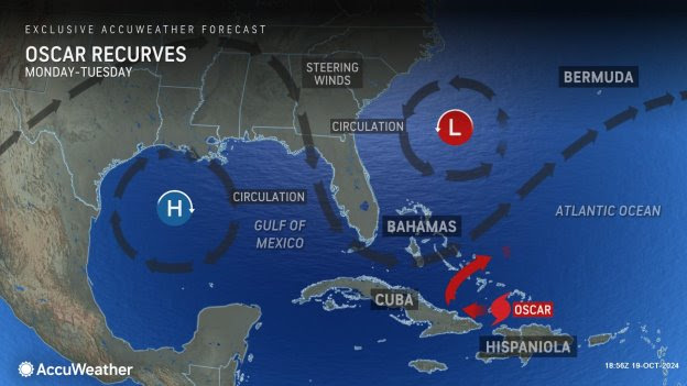
AccuWeather expert meteorologists say Oscar may intensify into a Category 2 hurricane before reaching Cuba Sunday afternoon. Oscar will turn northeastward early this week and move across the central Bahamas. Eventually, it will lose tropical characteristics as it accelerates northward later this week and merges with another non-tropical storm.
Heavy rain is expected across eastern Cuba where 4-8 inches can fall and 8-12 inches can fall right along the coast, with an AccuWeather Local StormMax™ of 14 inches. This heavy rain can lead to flooding and some mudslides across the mountainous terrain.
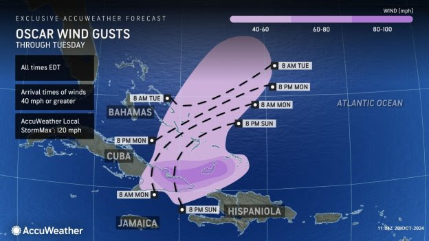
Strong winds will continue across the Turks and Caicos Islands through this morning, with gusts as high as 80-100 mph with an AccuWeather Local StormMax™ of 120 mph. These winds will then impact eastern Cuba later this afternoon into Monday. Widespread power outages and damage to structures will occur. Power outages in eastern portions of Cuba could last for weeks as the storm moves across areas with many small, remote communities. Tropical storm-force winds will then impact the central and southern Bahamas early this week as Oscar makes a turn to the northeast. Winds of this magnitude can bring down trees and power lines and cause some damage to structures across parts of the Bahamas.
AccuWeather expert meteorologists say there will be a 1- to 3-foot surge on the northeast coast of Cuba with a 3- to 6-foot surge around Nipe Bay westward to Gibara.
“Some people were surprised by the quick intensification of the tropical rainstorm into Tropical Storm Oscar and then Hurricane Oscar on Saturday afternoon, but AccuWeather customers were not surprised. AccuWeather hurricane experts had been exclusively and consistently forecasting a tropical storm north of the Dominican Republic on Saturday since Monday afternoon, Oct. 14,” said Porter. “AccuWeather hurricane experts issued the only known track and intensity forecast for the storm on Oct. 14 and then continuously held the forecast for the tropical rainstorm to become a tropical storm bringing damaging winds and flooding rainfall to parts of the northern Caribbean, which once again enabled AccuWeather customers to be better prepared and make the best decisions related to the storm. Conversely, the National Hurricane Center and other known sources had only a 10 percent risk for development on the storm as recently as late Friday afternoon.”
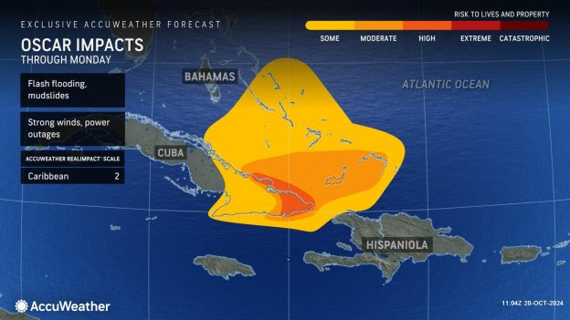
Due to flooding rainfall, mudslides, storm surge and gusty winds, Oscar is a 2 on the AccuWeather RealImpact™ Scale for Hurricanes in the Caribbean.
A 2 on the AccuWeather RealImpact™ Scale for warnings of moderate flooding, significant wind damage to small buildings, mobile homes and trees, as well as power outages and significant property damage from coastal inundation.
“Our goal is to provide the most advance notice so that people can make the best decisions and stay safer. Oscar is the most recent of many such examples of AccuWeather’s proven Superior Accuracy. All other known sources, including the National Hurricane Center, seemed to have been lulled into a false sense of security with this storm because computer forecast guidance unanimously showed the storm dissipating. AccuWeather hurricane experts felt this was incorrect due to our analysis of a favorable environment for intensification that the storm would be moving through north of the Dominican Republic. This environment was characterized by lowered wind shear and just enough atmospheric moisture for intensification,” Porter explained. “AccuWeather expert meteorologists had noted all week long that while the storm was surrounded by areas of dry air, it was able to maintain an envelope of atmospheric moisture around it, which led us to believe that when the unfavorable wind shear backed off a bit into the weekend, the storm would intensify into a tropical storm. AccuWeather hurricane experts had also correctly identified that the overall jet stream configuration over the United States and the Caribbean also favored tropical storm development with a prime area for development located well south and underneath a large area of high pressure over the eastern United States.”
Porter says impacts from our warming atmosphere and warming water temperatures have played a major role in rapid intensification this year.
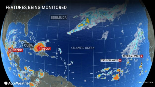
“AccuWeather hurricane experts have been better integrating the impacts driven in large part by climate change this entire hurricane season, such as the impact of record high water temperatures across much of the Atlantic basin. An important consideration of the AccuWeather forecast for Oscar was that Oscar would be traversing water temperatures 3-6 degrees above the historical average, which favored the development of a tropical storm given our analysis of an improved atmospheric setup for tropical storm development,” said Porter.
Additional AccuWeather Resources:
AccuWeather RealImpact Scale for Hurricanes
Tracking Nadine and Hurricane Oscar
AccuWeather Hurricane Center
Rapid intensification: How hurricanes gain strength and why it’s so dangerous
For the latest news and updates visit AccuWeather.com
About AccuWeather, Inc. and AccuWeather.com – AccuWeather, recognized and documented as the most accurate source of weather forecasts and warnings in the world has saved tens of thousands of lives, prevented hundreds of thousands of injuries and tens of billions of dollars in property damage. With global headquarters in State College, PA and other offices around the world, AccuWeather serves more than 1.5 billion people daily to help them plan their lives and get more out of their day through radio, television, newspapers, smart phones, tablets, connected TVs, the AccuWeather Network and AccuWeather.com. Additionally, AccuWeather produces and distributes news, weather content, and video for more than 180,000 third-party websites.
There is no better place to track the storm and its impacts than AccuWeather.com, the free AccuWeather mobile apps, the AccuWeather TV Network or AccuWeather partner outlets.


