RAFAEL STRENGTHENING AS IT HEADS TOWARDS THE CAYMAN ISLANDS
From National Hurricane Center


Tropical Storm Rafael Discussion Number   9
NWS National Hurricane Center Miami FL       AL182024
400 PM EST Tue Nov 05 2024

Reports from an Air Force Reserve Hurricane Hunter aircraft and
radar data from Grand Cayman indicate that Rafael has developed an
inner wind core during the past several hours.  The radar data shows
the development of a ragged eye, and the Hurricane Hunter reported
850-mb flight-level winds of 73 kt about 30-35 n mi northeast of the
center. The aircraft also reported that the central pressure has
fallen to near 989 mb.  Based on these data, the initial intensity
is increased to 60 kt.  The wind radii have been revised some based
on the aircraft data.

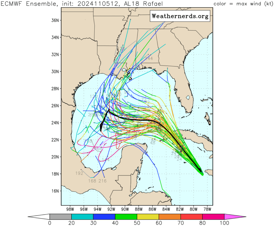
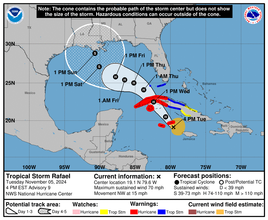
The initial motion is northwestward at 325/13 kt.  Rafael is
currently on the southwestern side of a low- to mid-level ridge over
the western Atlantic, and this feature should steer the cyclone
generally northwestward for the next 36-48 h, with the center
passing near the Cayman Islands and over western Cuba. From 48-72
h, the models are in better agreement that the center should turn
more westward as the ridge builds a little westward along the
northern Gulf coast.  After 72 h, there remains some significant
spread in the track guidance, due partly to differences in how fast
Rafael will shear apart and due partly to differences in the
forecast strength of the ridge along the Gulf coast.  The GFS
weakens the ridge and shows a northward turn, while the ECMWF keeps
a stronger ridge and shows a more westward motion.  The
deterministic UKMET has now changed to a northward turn scenario,
but the HWRF, HMON, and UKMET ensemble mean join the ECMWF with a
westward motion.  As mentioned with the previous forecast, until
there is a clearer signal on which of these scenarios is more
likely, the forecast compromises between these extremes with a slow
turn toward the north over the northern Gulf of Mexico.

Now that Rafael has developed an inner wind core, conditions are
favorable for steady to rapid strengthening during the next 24 h or
so.  The system is expected to reach hurricane strength during
the next several hours as it passes through the Cayman Islands with
additional strengthening before it reaches Cuba.  While the peak
intensity forecast is near the high end of the intensity guidance,
there is a chance that Rafael could get stronger than currently
forecast. Once the center is north of 25N in the Gulf of Mexico,
the cyclone is likely to encounter increasing vertical wind shear,
dry air entrainment, and cooler sea surface temperatures, which
should lead to Rafael weakening and eventually shearing apart
vertically. This part of the intensity forecast lies near or just
above the intensity consensus.


Key Messages:

1. Rafael is forecast to be a hurricane when it passes near or over
the Cayman Islands during the next 12 hours, where damaging
hurricane-force winds, a dangerous storm surge, and destructive
waves are expected. Additional strengthening is expected before
Rafael reaches western Cuba and the Isle of Youth on Wednesday. A
hurricane warning is in effect for this region, where damaging
hurricane-force winds, life-threatening storm surge, and destructive
waves are also expected.

2. Tropical storm conditions are expected in the Lower and Middle
Florida Keys beginning Wednesday and Wednesday night.

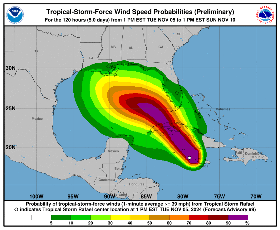
3. It is too soon to determine what, if any, impacts Rafael could
bring to portions of the northern Gulf Coast.  Residents in this
area should regularly monitor updates to the forecast.

4. Rafael will bring areas of heavy rain across portions of the
western Caribbean through early Thursday, including  Jamaica and the
Cayman Islands, along with southern and western portions of Cuba.
Flash flooding and mudslides are possible along the higher terrain
in Jamaica and Cuba.


FORECAST POSITIONS AND MAX WINDS

INIT  05/2100Z 19.1N  79.6W   60 KT  70 MPH
 12H  06/0600Z 20.5N  80.7W   70 KT  80 MPH
 24H  06/1800Z 22.5N  82.4W   80 KT  90 MPH
 36H  07/0600Z 24.1N  83.8W   80 KT  90 MPH
 48H  07/1800Z 25.0N  85.2W   80 KT  90 MPH
 60H  08/0600Z 25.4N  86.5W   75 KT  85 MPH
 72H  08/1800Z 25.8N  87.8W   65 KT  75 MPH
 96H  09/1800Z 27.1N  90.1W   50 KT  60 MPH
120H  10/1800Z 28.8N  90.7W   40 KT  45 MPH

$$
Forecaster Beven

END

From Weathernerds:
