Major hurricane forecast to develop in the Caribbean; Increasing risk of impacts in Florida
> AccuWeather is forecasting a Category 3 hurricane to develop in the western Caribbean Sea this weekend
> Life-threatening flooding rainfall is possible in parts of the Yucatan Peninsula of Mexico, Honduras and Nicaragua with an AccuWeather Local StormMax™ of 36 inches
> Increasing risk of rain and wind impacts in Florida next weekif the storm turns northeast
AccuWeather Global Weather Center – Nov. 13, 2024 – AccuWeather hurricane experts are sounding the alarm for a major hurricane threat in the Caribbean Sea that could bring dangerous impacts to areas of Central America later this week.
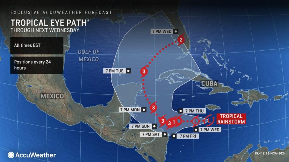
AccuWeather Lead Hurricane Expert Alex DaSilva says the storm could take a northeastward turn early next week and potentially bring impacts to parts of Cuba and Florida.
“All of the conditions are coming together to allow this storm to intensify rapidly. There is plenty of moisture, low wind shear and very warm water temperatures. We don’t see any obstacles that could prevent this storm from exploding into a major hurricane,” said DaSilva. “This storm will likely become our 12th hurricane of the season, which is a testament to the supercharged nature of the season. The historical average is seven hurricanes.”
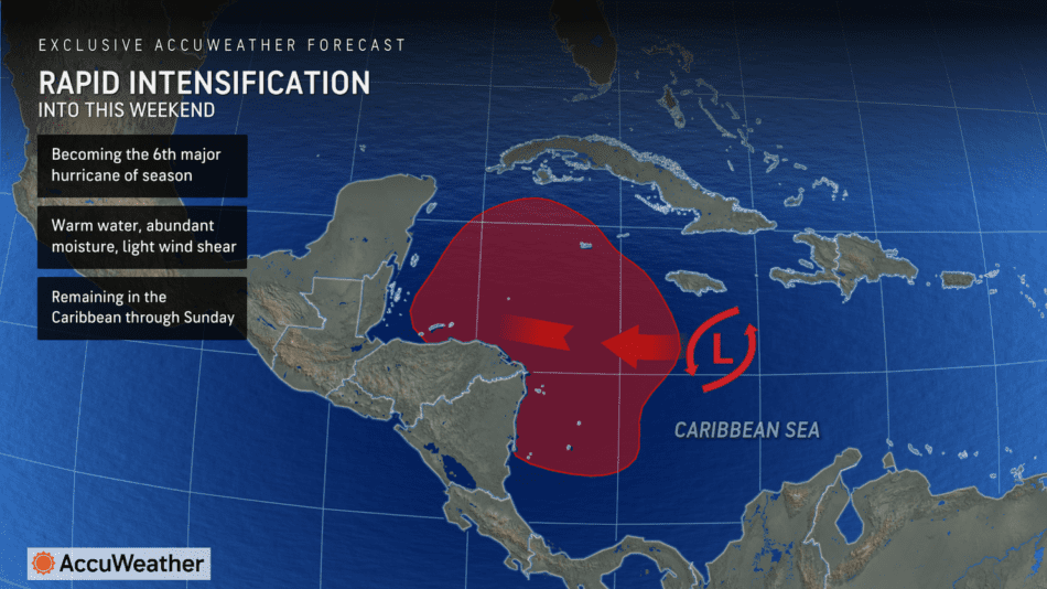

AccuWeather hurricane experts say a tropical rainstorm developed in the Caribbean on Tuesday night. AccuWeather uses the term “tropical rainstorm” to refer to certain tropical systems that can bring significant impacts from rain and wind prior to official classification as a tropical depression or storm to raise public awareness of their disruptive, damaging and dangerous potential. AccuWeather was the first known source to issue a track and intensity forecast Tuesday night, providing more advance notice to help people prepare.
The tropical rainstorm is expected to organize over the next 72 hours in the western Caribbean, north of Honduras. Because environmental conditions remain conducive for development, including very warm ocean waters and an absence of significant wind shear, it is expected to strengthen into a named tropical storm by Thursday. The next name on the Atlantic basin list is Sara.
AccuWeather Chief Meteorologist Jon Porter says this storm is expected to undergo rapid intensification into a major hurricane as it passes close to Central America. A major hurricane is a Category 3 or higher on the Saffir-Simpson Hurricane Wind Scale.
“These warm waters will act like high-octane rocket fuel for this brewing storm,” said Porter. “We want everyone in Florida to closely monitor forecast updates.”
AccuWeather Chief On-Air Meteorologist Bernie Rayno says families, businesses, emergency officials and government leaders across southern and central Florida need to be prepared for potential impacts next week.
“This is a recipe for explosive intensification,” Rayno said. “Everyone needs to be prepared for the possibility of a hurricane landfall along the Gulf coast of Florida next week. It’s time to get ready.”
Impacts in Central America & Cuba
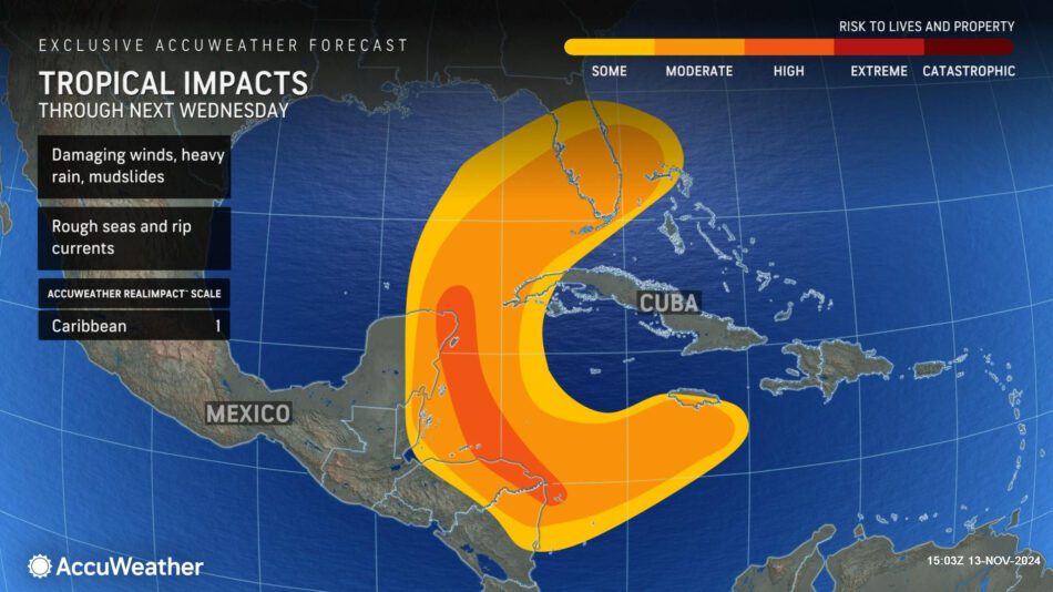
As the tropical rainstorm tracks to the west over the western Caribbean, a wide swath of 2 inches of rain or more is expected across southern Jamaica, far eastern Nicaragua and Honduras through this weekend. The storm is then expected to shift northward, bringing heavy rain across eastern portions of the Yucatan Peninsula and western Cuba into early next week. The heaviest rain is expected along the east coasts of the Yucatan Peninsula, Honduras and Nicaragua, where more than 8 inches of rain can fall, with an AccuWeather Local StormMax™ of 36 inches.
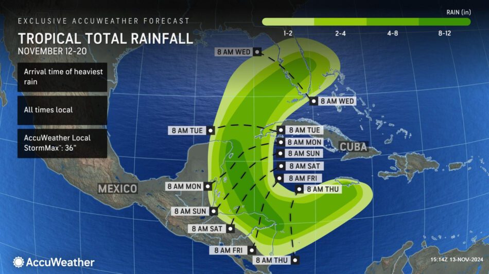

This heavy rain can lead to major flooding, landslides and significant travel disruptions across eastern portions of Central America.
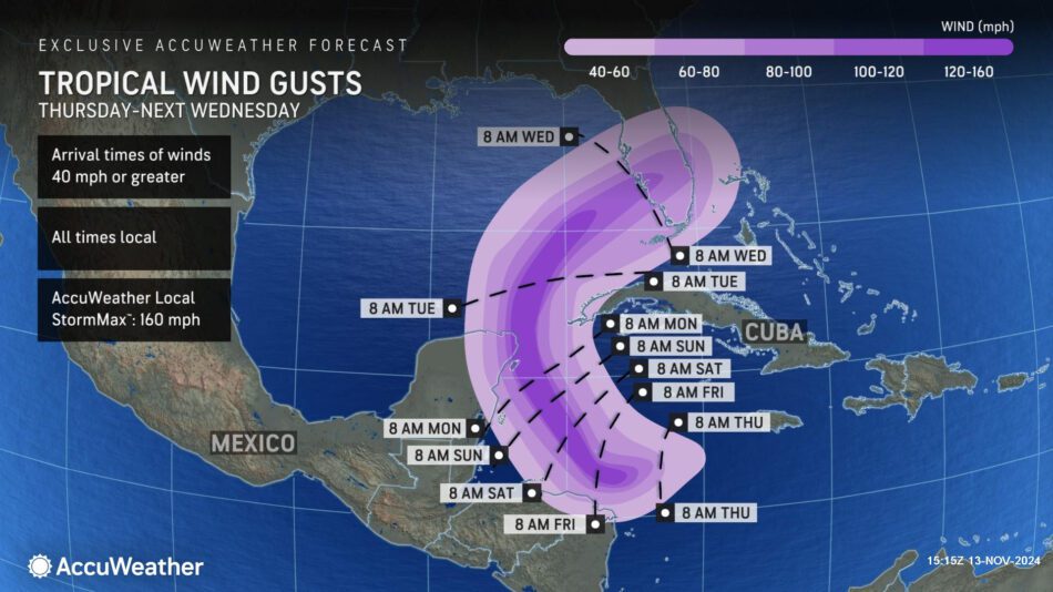
AccuWeather hurricane experts say wind gusts of at least 40 mph are expected along the coast of Honduras, as well as across eastern portions of the Yucatan Peninsula and far western Cuba as the storm gains wind intensity. As the storm passes just to the east of the Yucatan Peninsula, destructive winds of at least 120 mph are forecast along the far northeastern coast, with an AccuWeather Local StormMax™ of 160 mph. Winds of this magnitude can lead to significant tree and structural damage as well as widespread and long-lasting power outages.

The tropical rainstorm is a1 on the AccuWeather RealImpact™ Scale for Hurricanes for the Caribbean, which warns of localized flooding and damage to unanchored mobile homes, vegetation and signs, as well as localized power outages and coastal inundation resulting in some property damage.

Any interaction with land will determine how much this storm could strengthen. AccuWeather hurricane experts say this storm could intensify into a Category 4 or a Category 5 hurricane if the storm tracks far enough away from land. If the storm does interact with land, it could limit the potential for strengthening.
Should the storm reach Category 4 intensity on the Saffir-Simpson Hurricane Wind Scale with maximum sustained winds of 130-156 mph, it would join a short list of November hurricanes since the satellite era began in the 1960s, which includes Iota and Eta from 2020, Paloma from 2008, Michelle from 2001 and Lenny from 1999. This storm has the potential to be the latest Category 4 hurricane on record in what has already been a very noteworthy season. Beryl, this past July, became the earliest Category 5 hurricane on record in the Atlantic basin.
AccuWeather hurricane experts say there is a possibility that the storm could track farther west than currently forecast. If an area of high pressure to the north of this storm is stronger, the storm is more likely to track westward into the Yucatan Peninsula with larger impacts for Central America. This scenario would likely limit the severity of any impacts on Cuba or Florida.
“Late-season tropical systems that emerge from the Caribbean have a history of turning toward Florida, which does not need any more impacts from tropical systems after several devastating storms this year,” said AccuWeather Senior Director of Forecasting Operations Dan DePodwin.
Additional AccuWeather Resources:
Hurricane Sara to soon form in Caribbean, track into Florida next week
Torrential downpours threaten flash flooding in southern, central US
2024 hurricane season names: Is your name on the list?
AccuWeather Hurricane Tracker


