Bermuda to be slammed by powerful winds and flooding rainfall from Hurricane Ernesto; Atlantic Canada needs to prepare for impacts

From AccuWeather
> Flooding rainfall, damaging wind gusts and storm surge are expected in Bermuda on Saturday
> Rough surf and dangerous rip currents will impact Atlantic coast beaches from Florida to Maine over the weekend
> Brief lull expected in tropical activity after Ernesto blows by Atlantic Canada early next week
AccuWeather Global Weather Center – Aug. 16, 2024 – Families, businesses and officials in Bermuda are being urged to prepare for storm surge, powerful winds and flooding rainfall as Hurricane Ernesto makes a close encounter with the islands this weekend.
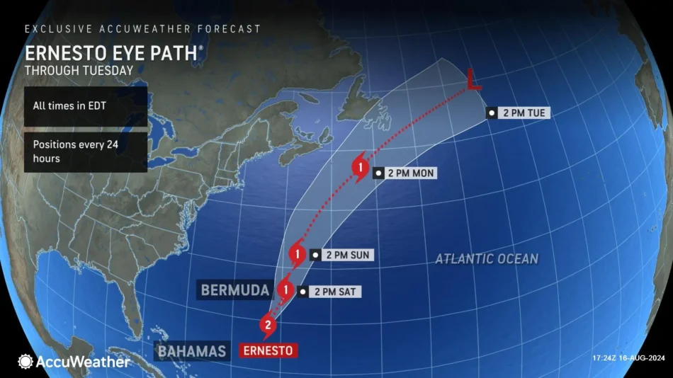
“Bermuda has already received a lot of rain from the frontal boundary that stalled over the past few days. A dip in the jet stream is pulling Ernesto toward Bermuda. We’re forecasting the hurricane to brush by Bermuda as it’s losing wind intensity,” explained AccuWeather Chief On-Air Meteorologist Bernie Rayno. “Bermuda is going to be in the right front quadrant of this storm; that’s the worst side of a hurricane to be on. The center of circulation will be off to the west of the islands. We expect high impacts from wind, rainfall and storm surge in parts of Bermuda.”
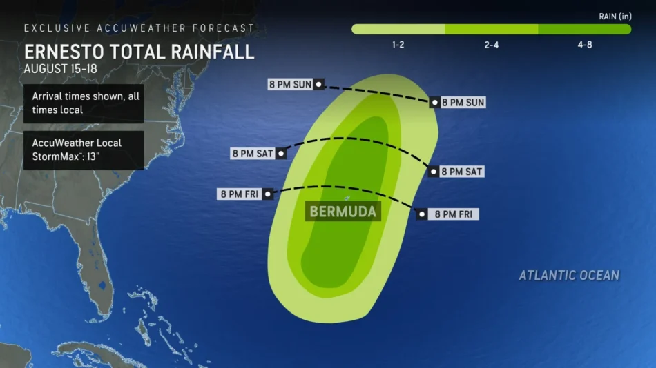
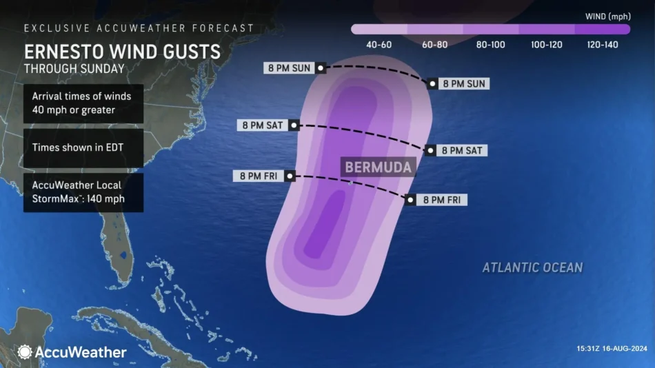
AccuWeather expert meteorologists are forecasting 4-8 inches of rainfall from Hurricane Ernesto, with an AccuWeather Local StormMax™of 13 inches. Strong wind gusts of 100-120 mph are expected in Bermuda on Saturday, with an AccuWeather Local StormMax™ of 140 mph. Families and businesses along the southern, western and eastern coasts of Bermuda should be prepared for 3 to 6 feet of storm surge.
AccuWeather Chief Meteorologist Jon Porter says Ernesto has the potential to shatter rainfall records from a hurricane in Bermuda.
“Everyone in Bermuda needs to be prepared for impacts from Ernesto,” said Porter. “We have a team of more than 100 expert meteorologists at AccuWeather. Once again, we were the first source to highlight the risk for this tropical threat to become a hurricane. We issued our first track forecast for this storm 24 hours before the National Hurricane Center and other sources.”
Powerful winds and drenching rainfall from Ernesto caused flooding and widespread power outages across Puerto Rico and parts of the Virgin Islands. AccuWeather expert meteorologists say utility crews, volunteers and residents working outdoors on repairs and cleanup should use caution in the heat. The AccuWeather RealFeel® Temperature in San Juan is forecast to hover above 100 degrees through Monday afternoon.
Due to the concerns for strong winds and flooding from heavy rain and storm surge, Ernesto is a 2 on the AccuWeather RealImpact™ Scale for Hurricanes for Bermuda.
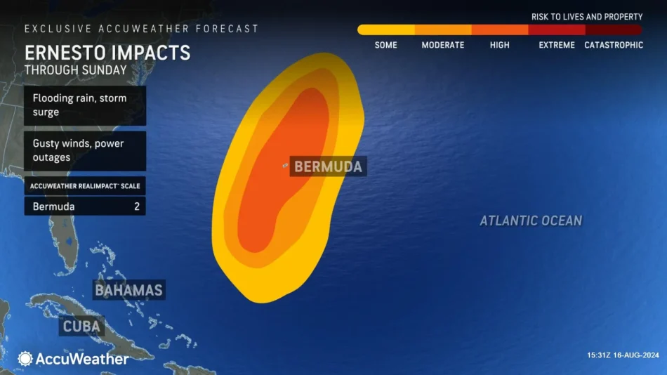
In contrast to the Saffir-Simpson Hurricane Wind Scale, which classifies storms by wind speed only, the AccuWeather RealImpact™ Scale is based on a broad range of important factors. In order to better communicate a more comprehensive representation of the potential impact of a storm to lives and livelihoods, the scale covers not only wind speed, but also flooding rain, storm surge and economic damage and loss. Some of these hazards such as inland flooding and storm surge in many storms result in more deaths and economic loss than wind.
Dangers at beaches along the U.S. East Coast
Hurricane Ernesto will remain hundreds of miles away from the U.S. Atlantic coastline, but Porter says the storm is creating rough surf and dangerous rip currents that could impact beaches from Florida to Maine.
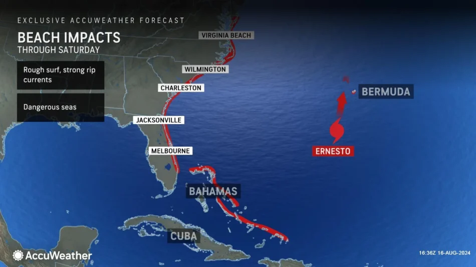
“This is a prime weekend for beach trips. Many families will be headed to the shore to squeeze in the last summer vacation or weekend at the shore. Please be aware that the surf could be higher and rougher than normal. There will be dangerous rip currents that can be tough to see,” said Porter. “We urge everyone headed to Atlantic beaches this weekend to stay in areas with lifeguards on duty. Take the time to learn about the warning signs and ways to escape a rip current. If you’re pulled out by a rip current, try to stay calm and swim parallel to the shore.”
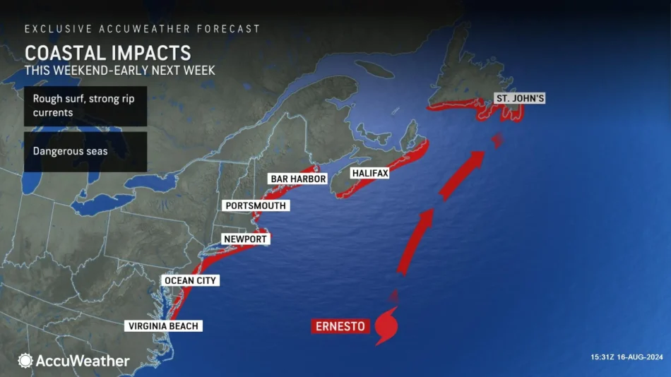
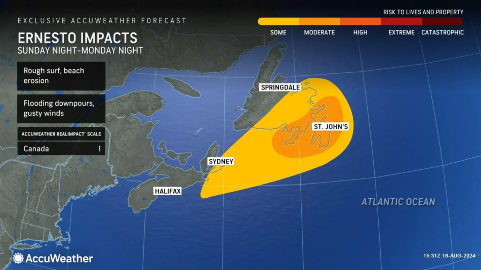
Atlantic Canada on alert for impacts
AccuWeather Lead Hurricane Expert Alex DaSilva says families, businesses and officials in Atlantic Canada need to be prepared for impacts to arrive late this weekend after Ernesto blasts Bermuda.
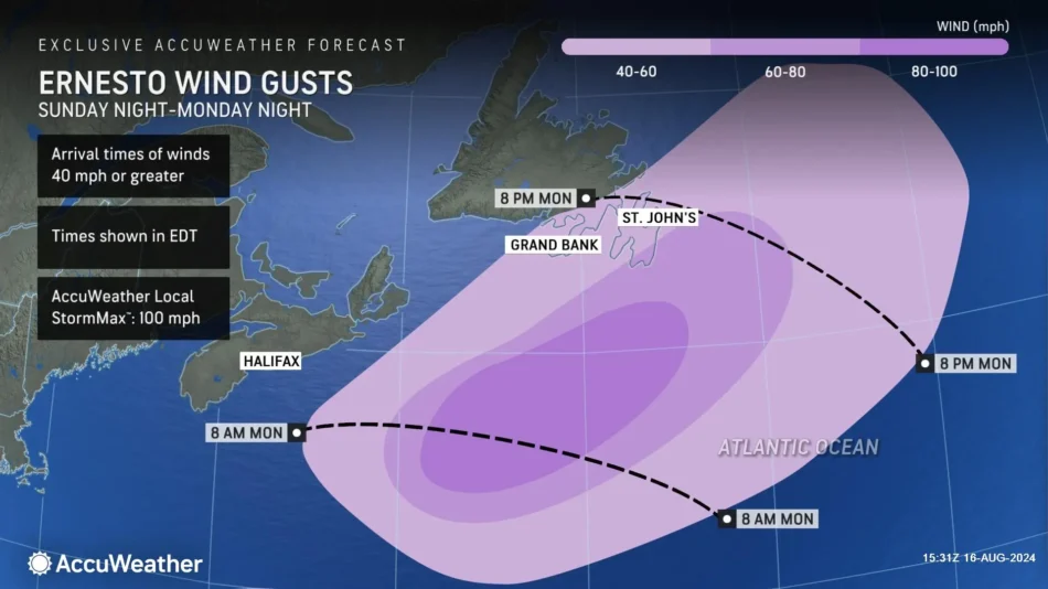
At this time, we believe Ernesto will be taking a north-northeast path as it approaches Atlantic Canada early next week, and that brings up the possibility of a landfall in Newfoundland,” said DaSilva.
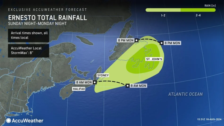
AccuWeather expert meteorologists say parts of Newfoundland could get 2-4 inches of rainfall from Ernesto with an AccuWeather Local StormMax™ of 8 inches. DaSilva says 60- to 80-mph wind gusts are expected in parts of Newfoundland, with an AccuWeather Local StormMax™ of 100 mph.
Due to the concerns for strong winds and flooding from heavy rain and storm surge, Ernesto is a 1 on the AccuWeather RealImpact™ Scale for Hurricanes for Atlantic Canada.
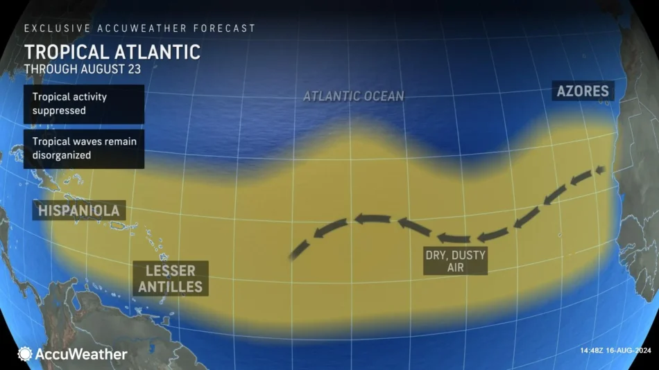
Tropics expected to go quiet for a week before an “explosion” of activity in September
After brushing by Atlantic Canada and moving out to sea, AccuWeather expert meteorologists expect a brief lull in tropical activity in the Atlantic basin.
Porter is warning families, businesses and officials not to let their guard down. AccuWeather expert meteorologists are forecasting the tropics to shift into high gear by the end of August.
“We expect a brief lull from tropical activity after Ernesto lasting a week or so. A lot of Saharan dust is expected to blow off the coast of Africa. The amount of Saharan dust over the Atlantic this season has reached near-record levels; that has reduced the number of named storms so far this season, but it won’t last for long,” explained Porter. “AccuWeather expert meteorologists expect the Saharan dust to clear out after a week or so, clearing the way for more tropical threats by the end of August.”
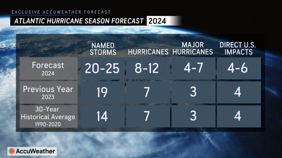
Porter said any lingering hurricane season preparations need to be completed soon, and hurricane supplies that were used during Hurricane Debby and Beryl need to be restocked, because a frenzy of tropical threats in the Atlantic basin are likely in September.
“The historic peak of hurricane season is on Sept. 10. We’re concerned that we could see multiple tropical threats by the middle of the month,” said Porter. “AccuWeather has not adjusted our Hurricane Season Forecast that was first released in March. Our expert meteorologists are confident that we’ll see an explosive season. AccuWeather is forecasting 20 to 25 named storms, which is well above the historical average. We’re also forecasting four to six direct impacts to the United States. The two direct impacts we’ve seen already this season from Hurricane Debby and Hurricane Beryl have been significant and taken a major financial toll on the U.S.”
Additional AccuWeather Resources:
Hurricane Tracking & Storm Radar
Hurricane Ernesto to threaten Bermuda, Canada
Dangerous rip currents from Hurricane Ernesto to impact US Atlantic beaches
Hurricane season update: What the US can expect into September, October
How to avoid the potentially deadly grip of a rip current
AccuWeather Forecasts Explosive 2024 Hurricane Season
Rapidly Intensifying Hurricanes Near Coastline Pose Major Threat To U.S. This Season