Caribbean Islands on alert for tropical storm impacts arriving later this week
From AccuWeather
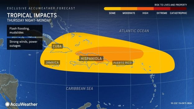
Growing risk of flooding rainfall and life-threatening mudslides in the mountainous terrain of Puerto Rico and Hispaniola
> An area of high pressure over the eastern United States should prevent impacts from this tropical rainstorm from reaching Florida
> Persistent onshore winds will cause rough surf, rip currents, and beach erosion along the Atlantic coast from the Florida Keys and South Florida through coastal Georgia
> AccuWeather experts say an extreme and unusual tornado outbreak last week caused billions of dollars of damage and economic loss as Hurricane Milton trekked across Florida
AccuWeather Global Weather Center – Oct. 15, 2024 – AccuWeather expert meteorologists are closely monitoring a tropical rainstorm that could trigger flooding rainfall, mudslides, and power outages in the Caribbean islands later this week.
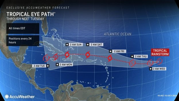
“We have been tracking a tropical wave that moved off the coast of Africa earlier this month,” said AccuWeather Lead Hurricane Expert Alex DaSilva. “This feature has been showing some signs of organization in recent days but could be entering a much more favorable area for tropical development this week as it nears the Leeward Islands in the northeastern Caribbean. It is possible for the feature to ramp up quickly to a tropical depression, tropical storm, or even a hurricane as its core approaches or passes near the Leeward Islands late this week. Farther west, the system is expected to re-enter an area of more hostile conditions that can prevent further strengthening and organization for a time.”
AccuWeather uses the term “tropical rainstorm” to refer to certain tropical systems that can bring significant impacts from rain and wind prior to official classification as a tropical depression or storm to raise public awareness of their disruptive, damaging and dangerous potential. Not all tropical rainstorms escalate to a depression or tropical storm.
AccuWeather was the first known source to issue a track and intensity forecast for this tropical rainstorm Monday evening. The next name on the Atlantic storm list is Nadine.
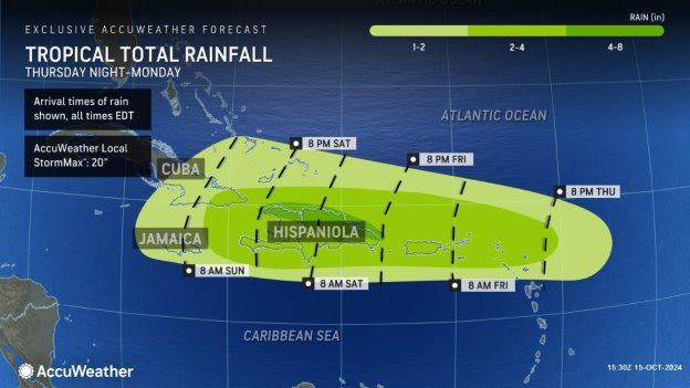
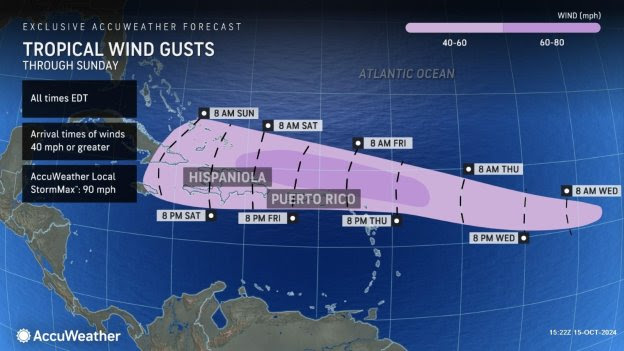
Rainfall amounts totaling 4-8 inches are forecast to impact northern areas of Hispaniola later this week, with an AccuWeather Local StormMax™ of 20 inches. The heaviest rain is expected over the rugged terrain of Hispaniola, where life-threatening mudslides can occur. Gusty, tropical-storm-force winds above 40 mph are also expected, which can lead to power outages and structural damage. The AccuWeather Local StormMax™ for winds is 90 mph.
“Mountainous terrain on these islands can essentially squeeze out precipitation like a sponge. Flooding rainfall and mudslides are a big concern in places like Puerto Rico and Hispaniola,” DaSilva said.
River Flooding and Rough Beach Conditions in Florida
AccuWeather Senior Meteorologist and Flooding Expert Alex Sosnowski says a strong area of high pressure over the eastern United States will help steer this storm away from the Southeast coast and prevent rain and wind impacts from reaching Florida, yet it will cause hazardous conditions along Atlantic beaches and coastal areas starting Wednesday through next Tuesday.
“This area of high pressure is providing Florida with protection from tropical systems brewing to the south, but it’s also creating hazards along the coast in the Southeast,” explained Sosnowski. “This area of high pressure over the East Coast is strengthening. That clockwise circulation is going to create an easterly flow that could last for a week or longer for locations to its south. These persistent onshore winds will push ocean waters toward the Atlantic coast. Some areas will be dealing with above-normal tide, coastal flooding at high tide, and significant beach erosion. This push of wind and water against the east coast of Florida will make it tough for these swollen rivers to recede.”
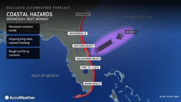
AccuWeather expert meteorologists say ongoing king tides and a persistent onshore flow will increase the risk of rough surf, rip currents, coastal flooding, and beach erosion from the Florida Keys and South Florida up through the Atlantic coast of Florida and coastal Georgia.
Sosnowski says families and businesses near flooded rivers in Florida could face weeks of impacts in the wake of Hurricane Milton.
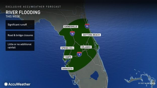
“This is a slow-moving disaster in Florida. The torrential rainfall and wind from Hurricane Milton are long gone. Now we’re dealing with 1 to 2 feet of rainfall working its way down the river systems. We’ve seen rivers in major flood stage and new records shattered over the past few days,” said Sosnowski. “The St. Johns River is a very slow-moving river that flows north. It just hit record levels over the weekend. We’re not out of the woods yet. Some places will be dealing with river flooding issues for weeks.”
Extensive Wind, Water & Tornado Damage from Back-to-Back Hurricanes
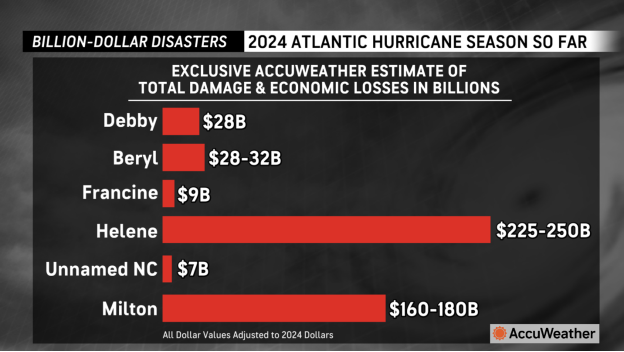
AccuWeather’s preliminary estimate for the total damage and economic loss in the United States from Hurricane Milton was between $160 billion and $180 billion.
Milton slammed Florida just two weeks after Hurricane Helene’s landfall. AccuWeather estimates the total damage and economic loss from Hurricane Helene in the United States is between $225 billion and $250 billion.
“Hurricane Milton brought destructive impacts across Florida. This will go down as one of the most costly and destructive hurricanes in Florida’s history,” said AccuWeather Chief Meteorologist Jon Porter. “We saw an extremely unusual and intense tornado outbreak in the tropical rainbands. Beach towns along the Gulf Coast that were just starting to recover from storm surge damage from Hurricane Helene were hit with storm surge and destructive winds again by Hurricane Milton. The heavily populated areas of Tampa, Orlando, and Daytona Beach faced damaging wind gusts and flooding rain. So many people across Florida have lost so much, they’re going to need a lot of help. The recovery process from these back-to-back hurricanes will take years in some places. AccuWeather estimates the total damage and economic loss from Milton and Helene will cost more than $400 billion.”
A total of 45 tornado reports were received and storm damage surveys are ongoing.
Most tornadoes from hurricanes are relatively weak, but three EF3 tornadoes rated on the Enhanced Fujita Scale from Hurricane Milton have been confirmed so far.
One of the EF3 tornadoes that moved from Fort Pierce to Vero Beach killed six people in the mobile home retirement community of Spanish Lakes near Port. St. Lucie, Florida. Many of the homes were destroyed.
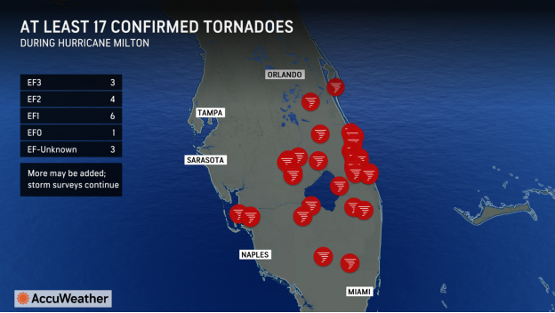
AccuWeather Meteorologist Jesse Ferrell says Hurricanes Beryl, Ivan, Frances and Rita each spawned only one EF3 twister each. Only one hurricane, Beulah, dropped more EF3s when it spawned eight tornadoes of that magnitude in Texas in 1967. No hurricane on record has ever caused an EF4 or EF5.
Because hurricanes contain so much rain, tornadoes during hurricanes are often wrapped in rain, making them difficult to see. Milton’s tornadoes all occurred during daylight hours. The storms that dropped the tornadoes across Florida last Wednesday were similar to low-precipitation supercell thunderstorms one might typically expect to see in Tornado Alley. Thanks to a dense network of traffic cameras, the Florida Department of Transportation caught at least three tornadoes on camera.
One of the EF3 tornadoes moved from the Miccosukee Reservation in the Everglades, across I-75, over the western tip of Lake Okeechobee through Sarasota Colony, and dissipated near the Brighton Seminole Reservation. This tornado track is 70.8 miles. Tornadoes from hurricanes are typically short-lived. If you look at every tornado ever reported in the U.S., you’ll find that only 0.23 percent are longer than 70.8 miles. Only one tornado from Hurricane Beryl, Ivan, Frances, Beulah, and Rita tracked for more than 28 miles, a 53.4-mile twister in Louisiana from Hurricane Beryl in July 2024.
Florida is not a state where long-track tornadoes typically occur. If the 70.8-mile twister goes into the record books, it will be the fifth-longest in the history of recorded tornadoes in the state and is the longest tornado south of a line from Bradenton to Palm Bay.
Counting preliminary tornado reports from Hurricane Milton, Florida has recorded 96 tornadoes this year, ranking it fifth in the continental U.S. behind Missouri, Illinois, Nebraska and Iowa, which are tied, and Texas.
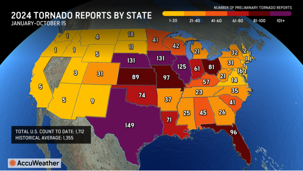
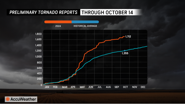
After a very active May, the U.S. has had a very active season with 1,712 tornadoes reported so far, compared to the historical average of 1,355.
Additional AccuWeather Resources:
Florida remains watchful amid brewing tropical activity
5 reasons Hurricane Milton’s tornado outbreak was historic


