Cayman: Latest models on Hurricane Ian UPDATE 26 Sep ’22 –
Sep 26 2022 5:30 am
All Models From weathernerds.org
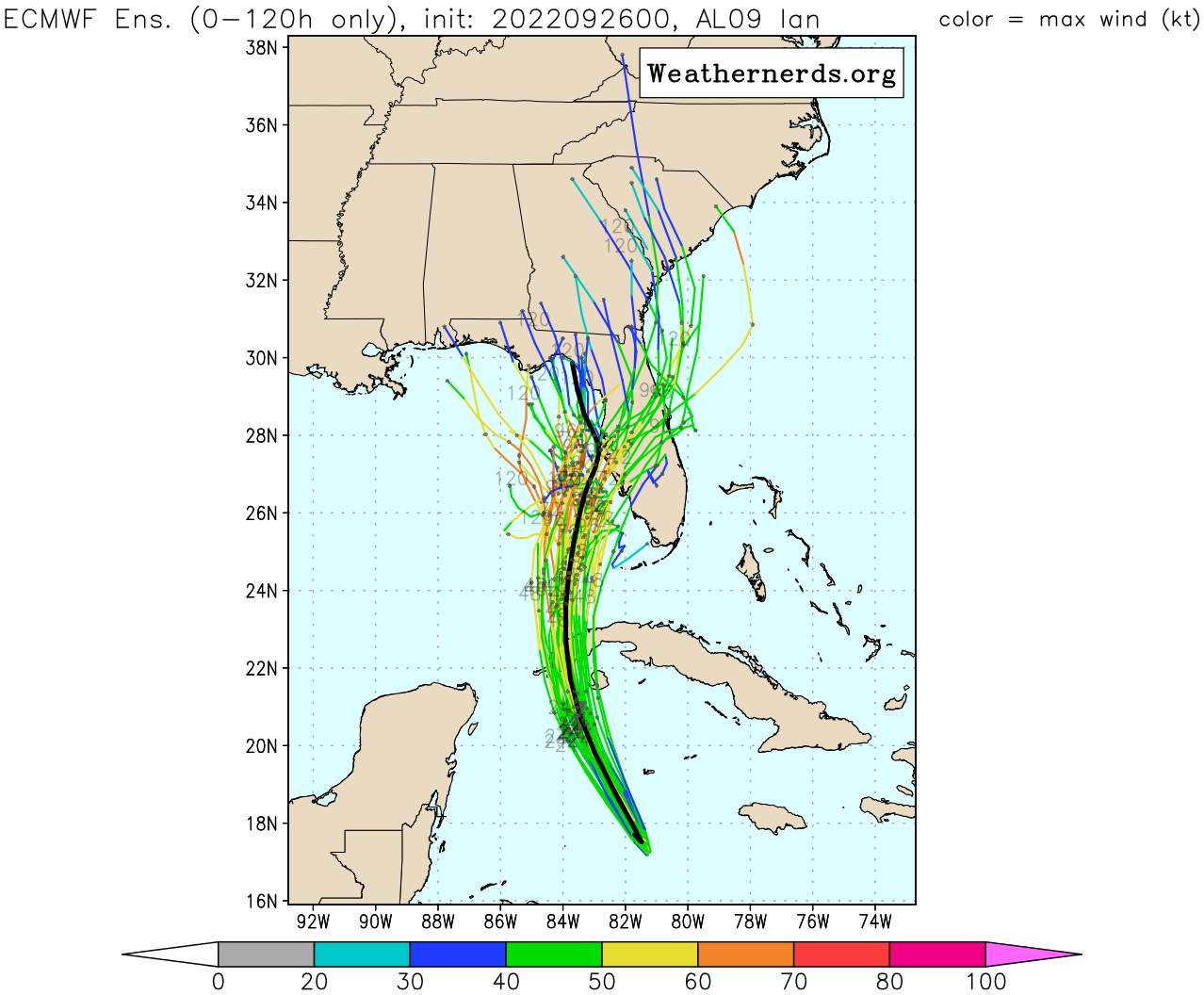
ECMWF Ensemble

NOTE on ECMWF Ensembles: These data are plotted directly as provided to the public by the ECMWF.
The vortex tracker may have difficulties tracking TCs or Invests, particularly weaker storms or
Invests that do not yet have an easily-identified location. Also, members that contain TC formation
that occurs later in the forecast (after 24 h, for example) may not be depicted in these tracks.

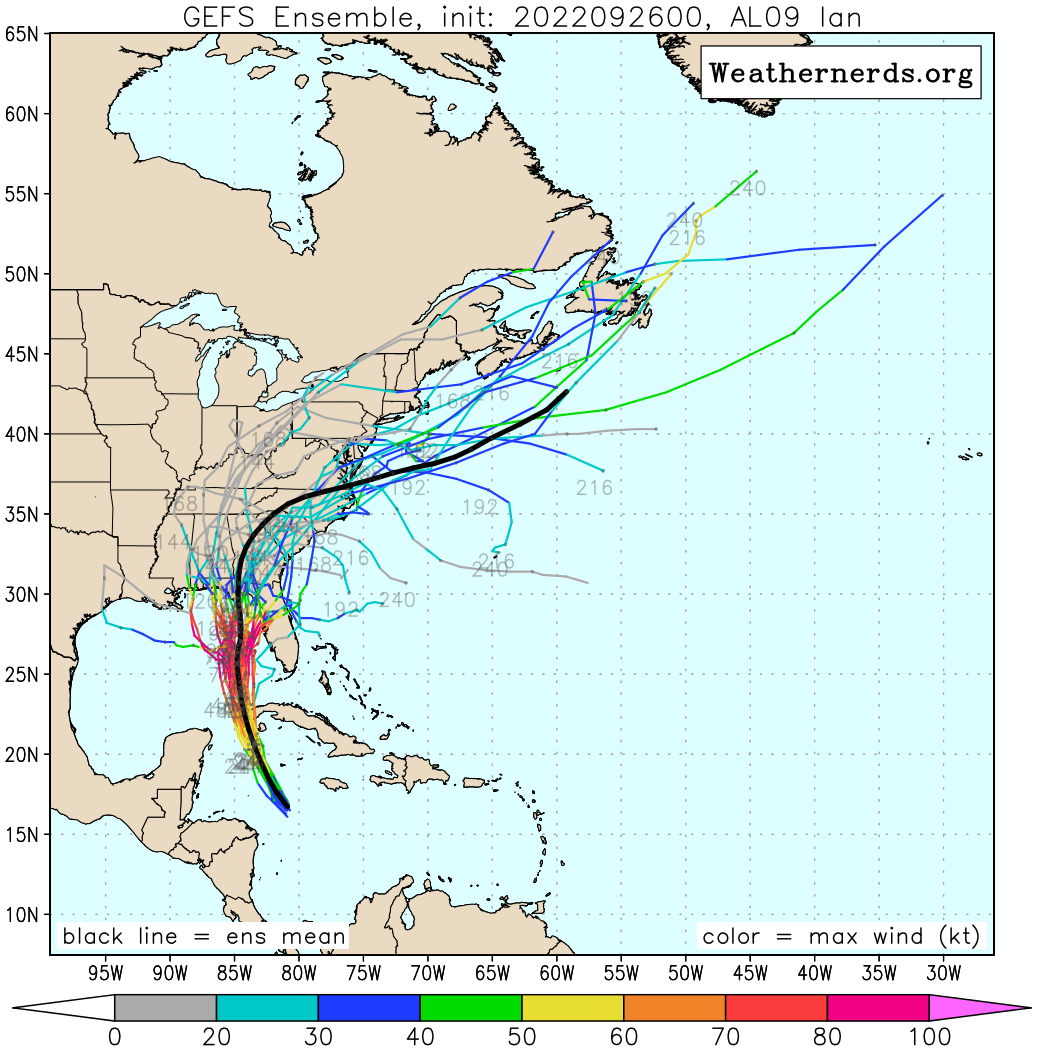
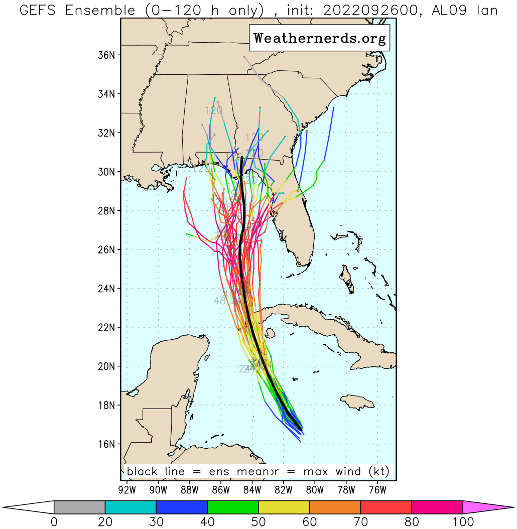
GEFS Ensemble


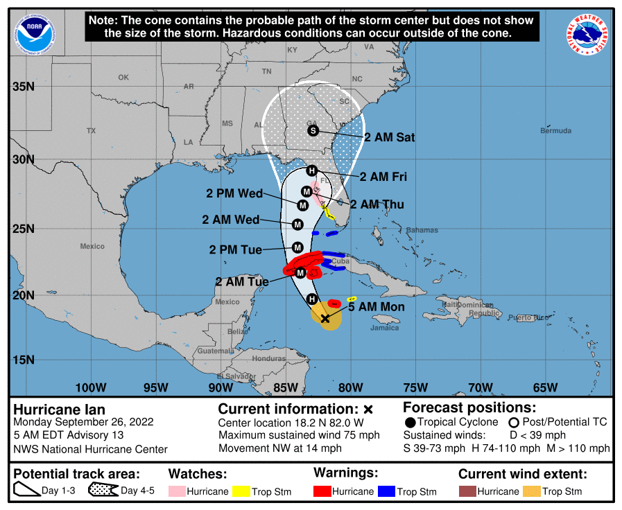

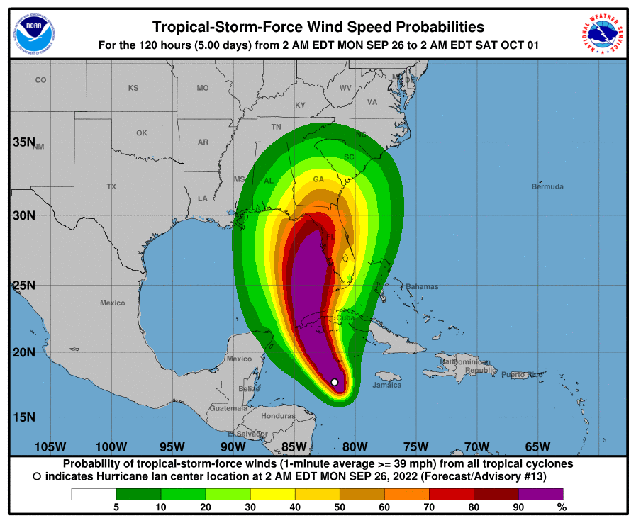

Hurricane Ian Discussion Number  13
NWS National Hurricane Center Miami FL       AL092022
500 AM EDT Mon Sep 26 2022

Satellite imagery shows that Ian has quickly become better organized
overnight. Banding has increased in all quadrants of the storm, and
the eye has become much better defined in radar data from Grand
Cayman.  The improving eye structure was also reported by an Air
Force Reserve reconnaissance aircraft that was in the storm
overnight.  During a single pass through the northeastern portion
of the storm the plane measured peak 700-mb flight-level winds of 71
kt and SFMR winds of 57 kt.  Given the continued increase in
organization and drop in central pressure on the latest center fix,
the initial intensity has been increased to 65 kt, making Ian the
fourth hurricane of the 2022 hurricane season.  The latest center
drop from the aircraft supported a minimum pressure of 983 mb.

In addition to the development of an inner core, the upper-level
outflow over the storm has expanded overnight.  Ian will be
traversing the warm waters (30 degrees C) of the northwestern
Caribbean and remain within very low shear conditions today. These
very conducive environmental factors along with the improved
structure of the storm are likely to result in rapid intensification
today, and Ian is forecast to be a major hurricane when it moves
near or over western Cuba tonight.  This is supported by the
majority of the intensity guidance, and the SHIPS Rapid
Intensification (RI) Index that gives a 90 percent chance of a
30 kt increase in wind speed over the next 24 hours, and about a 60
percent chance of a 40 kt increase in wind speed during that same
period.  Ian is not expected to spend much time over western Cuba,
and additional strengthening is likely over the southeastern Gulf
of Mexico on Tuesday.  Around 60 hours, a sharp increase in
southwesterly vertical wind shear and a drier mid-level environment
to the northwest of Ian is likely to induce some weakening.
Despite the reduction in intensity, Ian is likely to have an
expanding wind field and will be slowing down by that time, which
will have the potential to produce significant wind and storm surge
impacts along the west coast of Florida.

The initial motion estimate is 325/12 kt. Ian is expected to turn
northward around the western side of a mid-level ridge during the
next day or so.  Later in the period, a broad trough over the
eastern United States is forecast to induce a north-northeastward
motion, however the steering currents are forecast to weaken
around day 3, and a slower forward speed is expected by that time.
Although the track guidance is in good agreement during the first
48 hours, there is still significant spread after that time.  The
UKMET and ECWMF are still on the eastern side of the guidance and
show a track very near or over the west-central coast of Florida
while the GFS, HWRF, and HMON, and GFS ensemble mean are on the
western side with a track toward Appalachia Bay. The NHC track
forecast remains close to the TVCA multi-model consensus aid, and
is very similar to the previous official forecast. It should again
be stressed that there is still significant uncertainty in the track
of Ian, especially in the 3-5 day time frame, and users should not
focus on the details of the track forecast at longer time ranges.


Key Messages:

1.  Ian is expected to produce heavy rainfall and instances of
flash flooding and possible mudslides in areas of higher terrain,
particularly over Jamaica and Cuba.  Considerable flooding impacts
are possible later this week in west central Florida. Additional
flash and urban flooding, and flooding on rivers across the Florida
Peninsula and parts of the Southeast cannot be ruled out for later
this week.

2.  Life-threatening storm surge and hurricane-force winds are
expected in portions of western Cuba beginning late today, and
Ian is forecast to be at major hurricane strength when it is near
western Cuba. Efforts to protect life and property should be
rushed to completion.

3.  Ian is expected to be a major hurricane in the eastern Gulf of
Mexico during the middle of this week. Regardless of Ian’s exact
track and intensity, there is a risk of a life-threatening storm
surge, hurricane-force winds, and heavy rainfall along the west
coast of Florida and the Florida Panhandle by the middle of this
week.  Tropical Storm and Hurricane Watches have been issued for a
portion of the west coast of Florida and additional watches may be
required later today.


FORECAST POSITIONS AND MAX WINDS

INIT  26/0900Z 18.2N  82.0W   65 KT  75 MPH
 12H  26/1800Z 19.7N  83.0W   90 KT 105 MPH
 24H  27/0600Z 21.7N  83.9W  105 KT 120 MPH
 36H  27/1800Z 23.6N  84.1W  115 KT 130 MPH
 48H  28/0600Z 25.3N  84.1W  120 KT 140 MPH
 60H  28/1800Z 26.7N  83.7W  115 KT 130 MPH
 72H  29/0600Z 27.7N  83.4W  100 KT 115 MPH
 96H  30/0600Z 29.2N  83.0W   80 KT  90 MPH
120H  01/0600Z 32.0N  82.9W   35 KT  40 MPH...INLAND

$$
Forecaster Brown/Roberts


