Cayman: Severe Weather Update 4 a.m. Hurricane Beryl 4/JUL/24
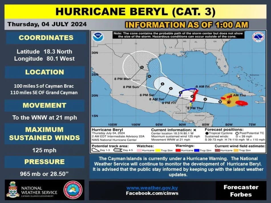
THE CAYMAN ISLANDS GOVERNMENT HAS ISSUED A HURRICANE WARNING FOR GRAND CAYMAN, CAYMAN BRAC AND LITTLE CAYMAN.
A Hurricane Warning means Hurricane conditions are likely within the next 36 hours.
Issued: Thursday 4 July 2024 – 4:30 AM
CURRENT STORM INFO:
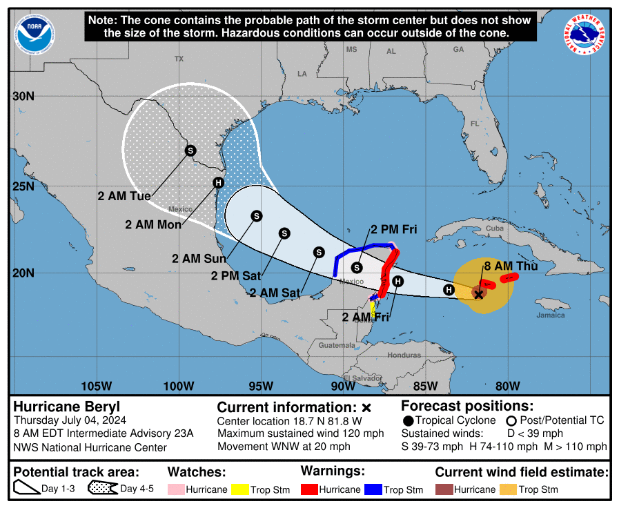
As of 4:30 AM, Hurricane Beryl was located at 18.5°N, 81.0°W, approximately 55 miles SSE of Grand Cayman and 110 miles SW of Cayman Brac. The hurricane is exhibiting maximum sustained winds of 120 mph and is moving WNW at a speed of 20 mph. The minimum central pressure recorded is 968 mb (28.59 inches).
BASED ON LATEST FORECAST TRACK
(Please note that the times provided may change. This could happen if the forward speed or the size of the wind field changes.)
Projected onset of Tropical Storm force winds:
- Cayman Brac: Currently Experiencing [Model Estimation]
- Little Cayman: Currently Experiencing [Model Estimation]
- Grand Cayman: Thursday 4 July, at 4:30 AM
- Grand Cayman: The center will pass 48 miles south at approximately 5:30 AM on Thursday, 4 July at 120 mph.
- Little Cayman: The center will pass 106 miles southwest at approximately 4:30 AM on Thursday, 4 July at 120 mph.
- Cayman Brac: The center will pass 110 miles southwest at approximately 4:30 AM on Thursday, 4 July at 120 mph.
End of Tropical Storm force winds:
- Cayman Brac: Thursday 4 July, at 6:00 AM
- Little Cayman: Thursday 4 July, at 7:00 AM
- Grand Cayman: Thursday 4 July, at 11:30 AM
IF THE STORM CONTINUES ON ITS LATEST FORECAST TRACK
Expected weather conditions for the Cayman Islands:
Grand Cayman:
Overcast skies with widespread thunderstorms are anticipated today. Tropical storm conditions are expected by early Thursday morning as Hurricane Beryl makes its closest approach to the Cayman Islands and begin to subside by early this afternoon. Widespread flooding is anticipated with the risk reducing by this evening as Hurricane Beryl moves away from the Cayman area. Extremely rough seas, significant swells, and some storm surge is expected to peak around Thursday morning and begin to subside by Thursday evening. Rough seas are still expected through Friday.
Sister Islands:
Similar conditions of overcast skies and widespread thunderstorms are expected today. The Sister Islands are expected to be experiencing tropical storm conditions, which are expected to subside by Thursday morning. Some flooding is anticipated with the risk reducing from Thursday evening. Extremely rough seas, significant swells, and some storm surge is expected to peak around early Thursday morning and begin to subside by Thursday afternoon. Rough seas are still expected through Friday.
WARNINGS
A FLOOD WARNING IS IN EFFECT FOR THE CAYMAN ISLANDS
Estimated Daily Rainfall:
Grand Cayman
- Thursday, 4 July: 50 to 100 mm (approximately 2 to 4 inches) with a potential for localized rainfall of 6 Inches.
- Friday, 5 July: less than 5 mm (approximately less than 0.2 inches)
- Saturday, 6 July: 15 to 20 mm (approximately 0.6 to 0.8 inches)
- Sunday, 7 July: 15 to 25 mm (approximately 0.6 to 1 inch)
- Monday, 8 July: less than 5 mm (approximately less than 0.2 inches)
Sister Islands
- Thursday, 4 July: 76 mm (approximately 3 inches)
- Friday, 5 July: less than 5 mm (approximately less than 0.2 inches)
- Saturday, 6 July: 10 to 15 mm (approximately 0.4 to 0.6 inches)
- Sunday, 7 July: 5 to 25 mm (approximately 0.2 to 1 inch)
- Monday, 8 July: less than 5 mm (approximately less than 0.2 inches)
GUSTY WINDS ARE EXPECTED FOR THE CAYMAN ISLANDS
Estimated Wind direction and Speeds
Grand Cayman
- Thursday Morning: E to SE at 45 to 55 knots (52 to 63 mph) with stronger gusts
- Friday Morning: SE at 10 to 15 knots (11 to 15 mph)
Sister Islands
- Thursday Morning: E to SE at 40 to 50 knots (46 to 58 mph) with stronger gusts
- Friday Morning: SE at 10 to 15 knots (11 to 15 mph)
A MARINE WARNING IS IN EFFECT FOR THE CAYMAN ISLANDS. ALL MARINE VESSELS ARE ADVISED TO SEEK AND REMAIN IN SAFE HARBOR UNTIL FURTHER NOTICE.
Estimated Wave Heights
- Thursday, 4 July: Waves of 10 to 15 feet accompanied by a storm surge of 2 to 4 feet, particularly along the south coasts.
- Friday, 5 July: Waves of 5 to 7 feet with swells, mainly along the south coasts.
THE NEXT BULLETIN WILL BE ISSUED AT 10:00 AM ON THURSDAY, 4 JULY 2024.


