CRFM 2024 Hurricane Season Bulletin No. 1 | Hurricane preparedness for an above average season

FROM THE EXECUTIVE DIRECTOR
In these times of increasing uncertainty, we can never be too prepared! The Caribbean Regional Fisheries Mechanism (CRFM) takes disaster preparedness seriously! At the CRFM, we recently developed our Emergency Response Plan and Disaster Recovery Plan, with support from the Caribbean Catastrophe Risk Insurance Facility Segregated Portfolio Company (CCRIF-SPC). Both plans were approved by the Ministerial Council of the CRFM when it met on 26 April 2024. These comprehensive plans are essential for guiding CRFM Secretariat staff through all phases of natural, manmade, and biological disasters and emergencies that may confront us. They can also serve as templates for similar plans of national fisheries divisions/departments and other associated entities in the region. We urge our Member States, partners, and stakeholders who have not yet done so to develop similar plans to ameliorate the potential adverse impacts and to guide recovery in the event that a disaster strikes.
The CRFM recognizes that knowledge sharing is critical to building our resilience! Therefore, we developed this bulletin to help our fisheries stakeholders, including fishing communities, with preparation and mitigation, as well as to encourage the sharing of information intended to protect lives and property.
Finally, we emphasize the need to always listen to and follow the official advisories from recognized authorities in your country, such as national emergency management and meteorological authorities. Stay alert and stay informed!

Milton Haughton, Executive Director,CRFM Secretariat

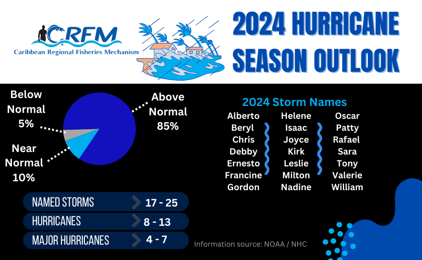
The Caribbean region will likely see above normal cyclone activity this year.
The 2024 Atlantic Hurricane Season, which spans 1 June to 30 November each year, is already upon us, and it is time to take stock of whether we are ready to face this above-normal hurricane season, which could produce as many as 25 named storms and 13 hurricanes, of which 7 could become major hurricanes, with wind speeds of 111 miles per hour or greater, according to the National Oceanic and Atmospheric Administration (NOAA) of the USA.
NOAA said, at its briefing of 23 May on the 2024 Atlantic Hurricane Season Outlook, that this increased activity is “due to a confluence of factors, including near-record warm ocean temperatures in the Atlantic Ocean, development of La Niña conditions in the Pacific, reduced Atlantic trade winds and less wind shear, all of which tend to favor tropical storm formation.
NOTE: A tropical cyclone is a generic term used by meteorologists to describe a rotating, organized system of clouds and thunderstorms that originates over tropical or subtropical waters and has closed, low-level circulation. Once a tropical cyclone reaches maximum sustained winds of 74 miles per hour or higher, it is then classified as a hurricane, typhoon, or tropical cyclone, depending upon where the storm originates in the world. In the North Atlantic [as well as the Caribbean and the Gulf of Mexico], central North Pacific, and eastern North Pacific, the term hurricane is used. (Source: NOAA)
UNDERSTANDING TYPES OF ADVISORIES
These are the main types of cyclone-related advisories:
- Tropical Depression Advisory
Provides information on the development and threat of a Tropical Depression which becomes a threat to land. The system is not named unless it was downgraded to a Tropical Depression from a Hurricane or Tropical Storm. Each new tropical depression is assigned a number, however. - Tropical Storm Advisory
Issued when the wind speed of a tropical cyclone reaches 39 mph (63 km/h) or higher. Tropical Storms are given names. - Hurricane Watch
Advisory issued for a particular area when conditions are favourable for the development of a hurricane. It does not necessarily mean that a hurricane is imminent. Hurricane watches will be issued when Hurricane conditions are possible along the coast within 48 hours (instead of 36 hours which was previously used). - Hurricane Warning
Issued when hurricane conditions are expected to affect a particular area within 36 hours (instead of 24 hours).
Courtesy CDEMA
PREPARE AND MITIGATE TO PROTECT LIVES AND PROPERTY
On Hearing Advisory
- Continue normal activities but stay tuned to radio and television for further messages.
Hurricane or Tropical Storm Watch
- Review emergency preparedness requirements, especially family emergency plans.
- Continue to listen to weather advisories on radio.
- Be ready to take quick action in case of a Warning.
- Establish contact points.
Hurricane or Tropical Storm Warning
- Stay tuned to the radio for information.
- Protect property and personal possessions (including important documents).
- Place indoors, loose objects found in and around the yard.
- Fill up car with gasoline.
- Pick fruit and trim trees if near house.
- Store water, food and essential medicines.
- Feed animals and pets and move indoors or loose.
- Know where you are going to shelter if the need arises.
After the Hurricane (or Tropical Storm)
- Assist in search and rescue.
- Seek medical attention for persons injured.
- Clean up debris and effect temporary repairs.
- Report damage to utilities.
- Assist in road clearance.
- Watch out for secondary hazards, fire, flooding, etc.
- Assist in community response efforts.
- Avoid sightseeing.
- Cooperate with Damage Assessors.
Courtesy CDEMA
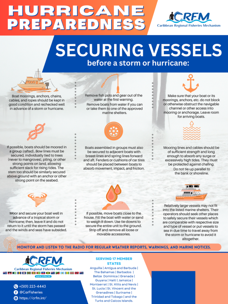
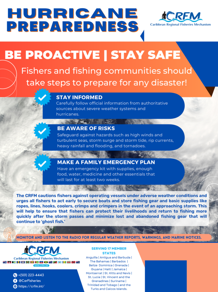
| CRFM Posters |


High quality image and PDF versions of these posters are available. Click the buttons below for direct access. Feel free to print and post in your organization or community, and share through email and social media with your networks.
Fishers struggling to secure boat when Tropical Storm Bret hit Dennery Village, Saint Lucia in June 2023
Courtesy Saint Lucia’s Chief Fisheries Officer, Mrs. Sarita Williams-Peter

screenshot. For video click HERE
| If you think this content can help someone you know, please feel free to share using the buttons below! You can also forward this email message (or the link to this message) to others who can benefit from the information. |


