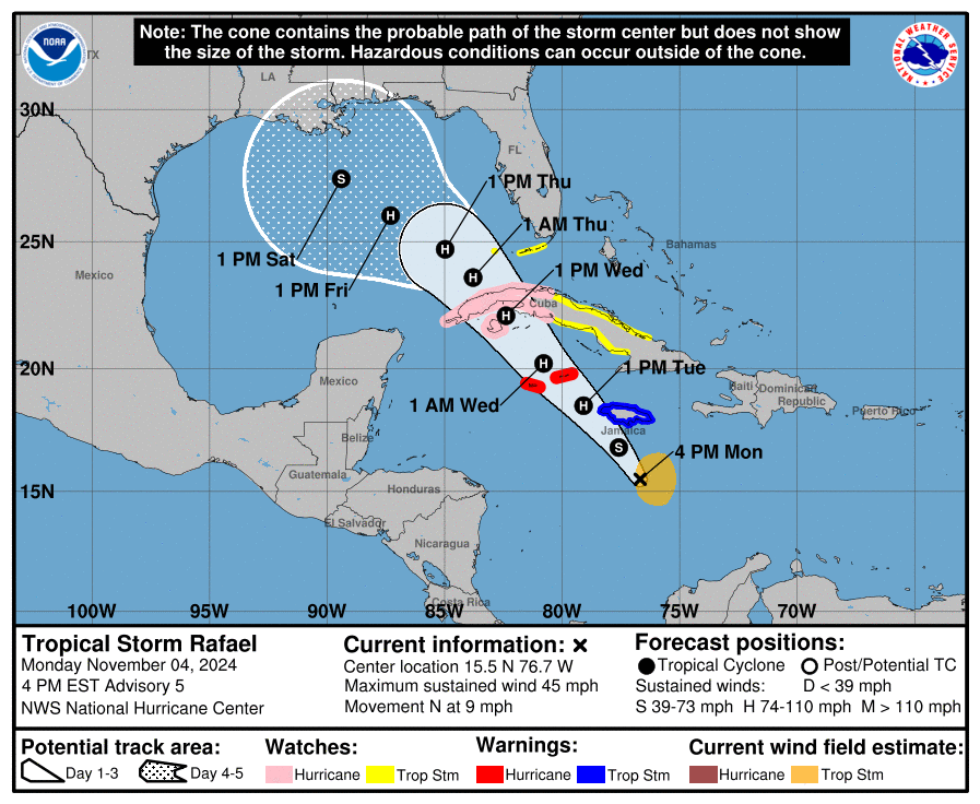
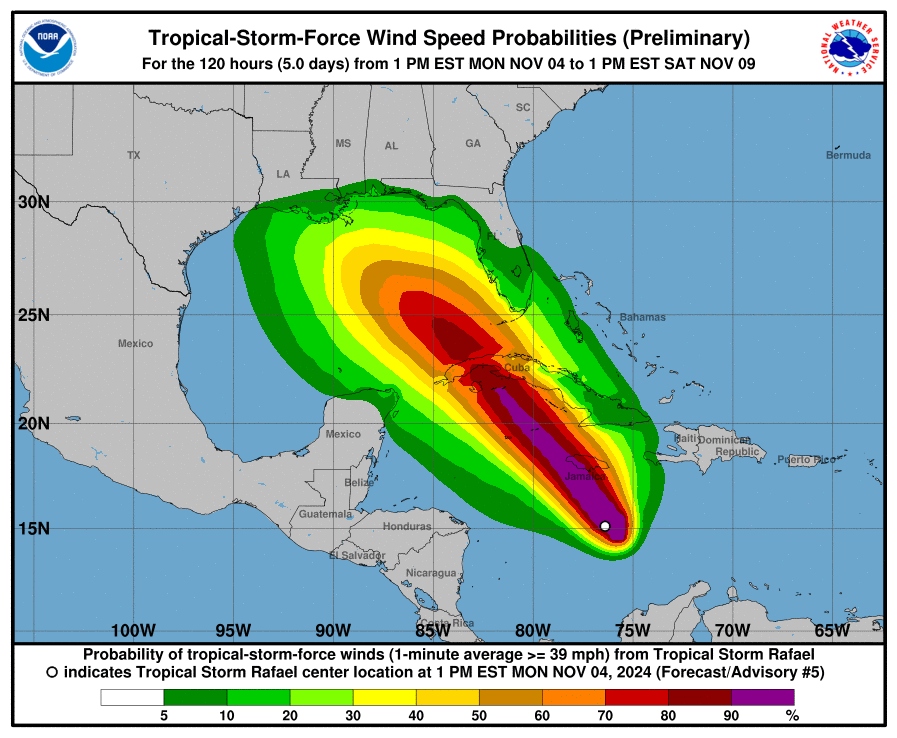
DEPRESSION STRENGTHENS INTO TROPICAL STORM RAFAEL… …TROPICAL STORM CONDITIONS EXPECTED TO BEGIN IN JAMAICA LATE TONIGHT (Hurricane conditions Cayman late Tue)
From NHC

Tropical Storm Rafael Discussion Number   5
NWS National Hurricane Center Miami FL       AL182024
400 PM EST Mon Nov 04 2024

Deep convection continues to burst near the center of the system,
with improving overall structure and curved banding depicted in
recent satellite images. Recent Air Force Hurricane Hunter data has
found flight level winds around 40-45 kt with higher SFMR values.
The Hurricane Hunters also indicated that an eyewall appears to be
developing. Based on the aircraft data, the intensity is being
increased to 40 kt. The system is now designated as Tropical Storm
Rafael, and is the seventeenth named storm of the Atlantic hurricane
season.

The storm has jogged a bit to the right of the previous track,
and the initial motion is estimated 010/8 kt. A turn to the
northwest is expected later tonight, and that motion is forecast to
continue during the next few days as a ridge builds over the
southwestern Atlantic and northeastern Caribbean. This motion should
take the center of the system near Jamaica tonight, near or over the
Cayman Islands by late Tuesday, and across western Cuba on
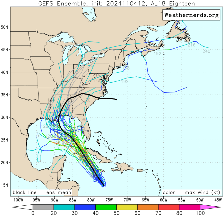
Wednesday. After that time, when the system reaches the Gulf of
Mexico, the model solutions diverge, which appears to be due to
differences in the steering patterns and vertical depth of the
storm. The NHC track forecast is largely an update of the previous
one and remains close to the various consensus models.  However, it
should be noted that the track forecast over the Gulf of Mexico is
of lower confidence.

Given the improving overall structure with an inner core developing,
combined with favorable environmental factors of low wind shear,
high moisture, and warm SSTs all support intensification. Models all
support steady to rapid intensification, and SHIPS RI probabilities
indicate a near 40 percent chance of a 30 kt increase in the next 24
hours and a near 50 percent chance of a 55 kt increase in 48 hours.
Thus, the latest NHC intensity forecast and peak intensity has been
increased and lies near the higher end of the guidance envelope
through the middle part of the forecast period. Based on the
SHIPS RI guidance, future upward intensity adjustments during the
first 48 h may be necessary in subsequent forecast cycles. In a
few days, when the system reaches the central Gulf, a sharp increase
in southwesterly vertical wind shear, drier air, and slightly cooler
waters should end the strengthening trend and induce weakening, and
the NHC intensity forecast follows these weakening trends and lies
near the HCCA and IVCN consensus aids through the end of the
forecast period.


Key Messages:

1. Rafael is forecast to be a hurricane when it passes near or over
the Cayman Islands by Tuesday evening where damaging hurricane-force
winds, a dangerous storm surge, and destructive waves are expected.
Tropical storm conditions are expected in Jamaica tonight and
Tuesday.

2. Additional strengthening is forecast before Rafael reaches
western Cuba and the Isle of Youth on Wednesday where there is an
increasing risk of a dangerous storm surge and damaging
hurricane-force winds.

3. Tropical storm conditions are possible in the Lower and Middle
Florida Keys beginning late Wednesday or Wednesday night.

4. It is too soon to determine what, if any, impacts Rafael could
bring to portions of the northern Gulf coast.  Residents in this
area should regularly monitor updates to the forecast.

5. Rafael will bring areas of heavy rain to portions of the western
Caribbean, including Jamaica and Cuba through mid-week, where
flooding and landslides are possible.  Heavy rainfall will spread
into Florida and adjacent areas of the Southeast United States mid
to late week.


FORECAST POSITIONS AND MAX WINDS

INIT  04/2100Z 15.5N  76.7W   40 KT  45 MPH
 12H  05/0600Z 16.8N  77.6W   55 KT  65 MPH
 24H  05/1800Z 18.5N  79.1W   65 KT  75 MPH
 36H  06/0600Z 20.2N  80.8W   75 KT  85 MPH
 48H  06/1800Z 22.1N  82.4W   85 KT 100 MPH
 60H  07/0600Z 23.6N  83.8W   80 KT  90 MPH
 72H  07/1800Z 24.7N  85.0W   75 KT  85 MPH
 96H  08/1800Z 26.0N  87.3W   65 KT  75 MPH
120H  09/1800Z 27.4N  89.4W   50 KT  60 MPH

$$
Forecaster Kelly


