Evolving tropical storm in the Caribbean will bring flooding threat to Central America; impacts possible in Florida next week
AccuWeather Public Relations

> Interaction with land will limit the opportunity for rapid intensification into a hurricane
> Risk of catastrophic flash flooding disaster in parts of Honduras and Nicaragua through the weekend from slow-moving downpours
AccuWeather Global Weather Center – Nov. 14, 2024 – AccuWeather hurricane experts say a storm brewing in the western Caribbean is developing closer to the coast of Honduras and will likely not intensify rapidly due to increased land interaction expected over the next 72 hours.
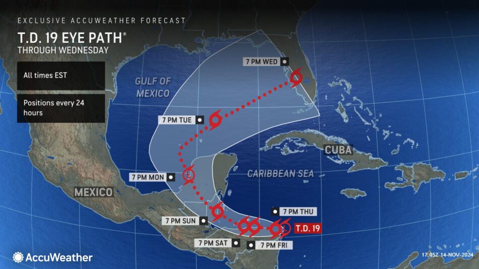
AccuWeather Chief Meteorologist Jon Porter says the slow-moving storm poses a dangerous flooding threat in parts of Central America through the weekend.
“We’re concerned about the threat of a life-threatening and catastrophic flooding disaster in Honduras and Nicaragua,” said Porter. “Steering winds will become very weak and allow the storm to meander near the coast of Honduras. This is a bad scenario that will produce downpours with rainfall rates of 4 inches per hour or more. A slow-moving tropical storm over mountainous terrain is bad news. Persistent downpours over the same areas can trigger dangerous flooding and mudslides.
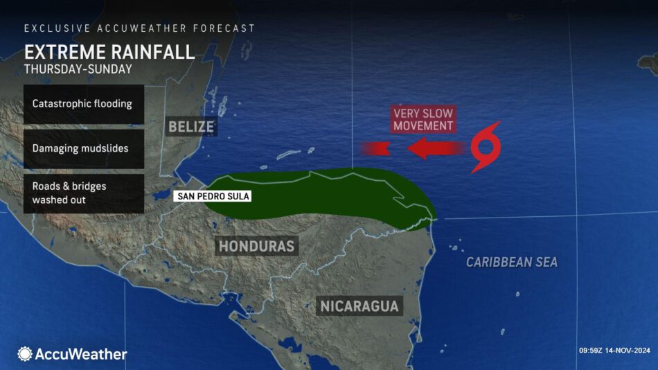
The next name on the list of tropical storms for the 2024 Atlantic hurricane season is Sara. This storm is expected to become the 18th named storm in the Atlantic basin this hurricane season.
This storm will impact portions of Honduras, Nicaragua, Belize and the Yucatan Peninsula as it tracks to the west through the end of the week.
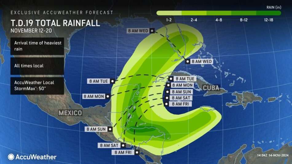
AccuWeather hurricane experts are forecasting 8-12 inches of rainfall possible across parts of Nicaragua, Honduras, Belize and the Yucatan Peninsula of Mexico through Tuesday. There is a zone across northern Honduras where 12-18 inches of rainfall is possible, with an AccuWeather Local StormMax™ of 50 inches.
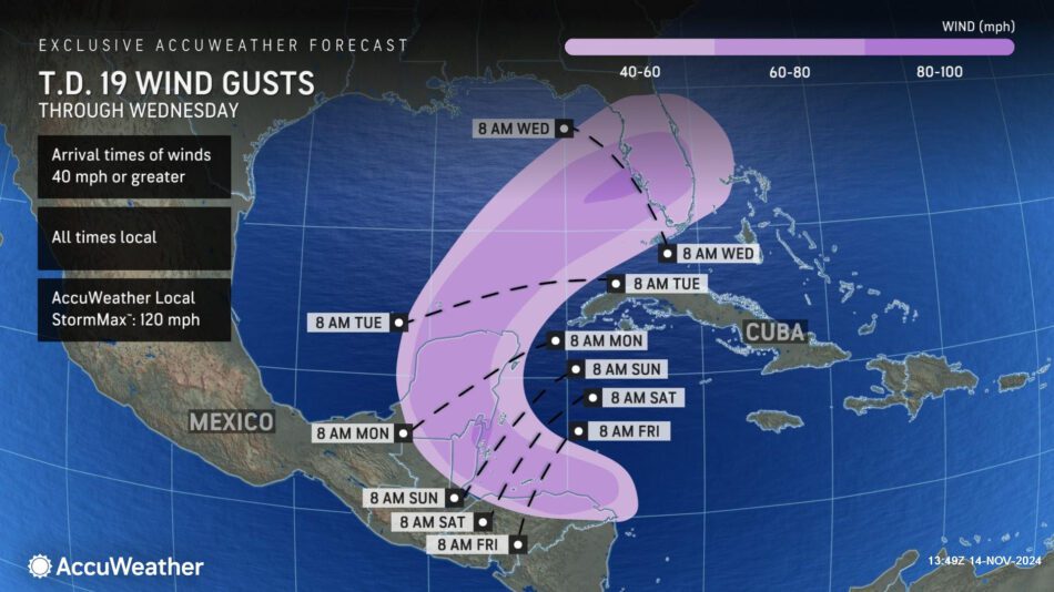
Wind gusts of 60-80 mph are possible in this region, with an AccuWeather Local StormMax™ of 120 mph. Winds of this magnitude can cause significant tree damage and extended power outages.
Due to the risk of torrential rainfall, mudslides, damaging winds and storm surge, this rainstorm is a 4 on the AccuWeather RealImpact™ Scale for Central America.
A 4 on the AccuWeather RealImpact™ Scale for Hurricanes warns of widespread catastrophic flooding and flooding issues that may last days to weeks, widespread power outages, structural damage to many buildings and severe coastal inundation.
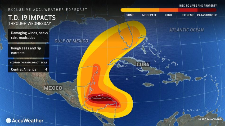
In contrast to the Saffir-Simpson Hurricane Wind Scale, which classifies storms by wind speed only, the AccuWeather RealImpact™ Scale is based on a broad range of important factors. In order to better communicate a more comprehensive representation of the potential impact of a storm to lives and livelihoods, the scale covers not only wind speed, but also flooding rain, storm surge and economic damage and loss. Some of these hazards such as inland flooding and storm surge in many storms result in more deaths and economic loss than wind.
“We cannot rule out the possibility that this storm could strengthen into a hurricane if it is able to avoid extended interaction with land. A matter of miles could make a big difference,” said Porter.
AccuWeather hurricane experts say this storm could turn toward the northeast once it crosses the Yucatan Peninsula and reaches the Gulf of Mexico.
“We now expect this storm to spend more time over land in Central America. That will reduce the wind intensity before it reaches the Gulf of Mexico. This storm could be drawn to the northeast by a departing area of high pressure over Florida. A dip in the jet stream over the central U.S. will create a pathway for this storm to be slingshotted toward Florida,” said Porter. “We could see heavy rainfall and flooding concerns in parts of central and south Florida next week. Florida does not need more tropical storm impacts. Many people are still recovering and trying to rebuild from hurricane landfalls earlier this year.”
There is also a scenario where the storm could be significantly disrupted by interaction with land over Central American and the Yucatan Peninsula that prevents it from restrengthening in the Gulf of Mexico. In this case, minimal or no impacts to the U.S. are more likely.
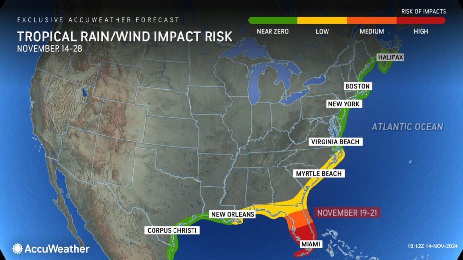
Porter is urging families, businesses, emergency officials and government leaders to closely monitor AccuWeather forecast updates for potential impacts in Florida next week.
Additional AccuWeather Resources:
Sara to soon form in Caribbean, track into Florida next week
2024 hurricane season names: Is your name on the list?
AccuWeather Hurricane Tracker
END
UPDATE: EDITOR – This storm has now formed and been named as SARA


