Gulf of Mexico disturbance bringing heavy rains to Florida, and may develop
 Dr. Jeff Masters From Weather Underground
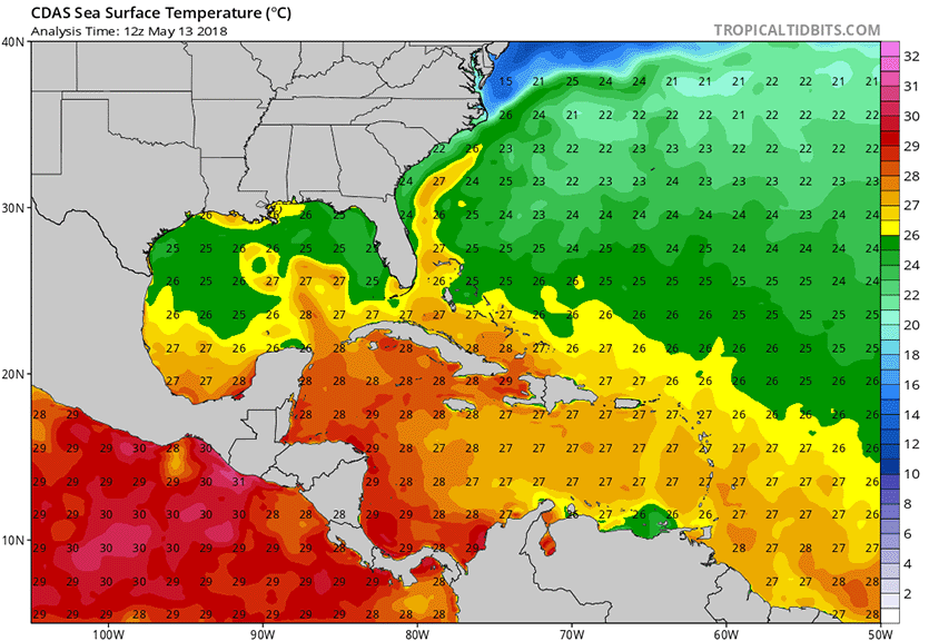
The Atlantic hurricane season officially starts on June 1, but we could see a tropical or subtropical depression form in the Gulf of Mexico this week, off the coast of the Florida Panhandle. A broad area of low pressure has developed over the southeastern Gulf of Mexico, in association with an upper-level low pressure system, and this area of disturbed weather is expected to drift slowly northward and stall out off the coast of the Florida Panhandle on Tuesday. By Wednesday, the low is expected to be absorbed by a trough of low pressure passing to its north, resulting in the low moving ashore along the Florida Panhandle, on either Wednesday or Thursday. As this low meanders over the warm waters of the Gulf of Mexico early this week, the system has the potential to gradually acquire tropical characteristics and become warm-cored, potentially becoming a tropical or subtropical depression. Sea surface temperatures (SSTs) off the coast of the Florida Panhandle are near 25°C (77°F)—a little cooler than is typically needed to see a tropical depression form, but plenty warm enough to support formation of a subtropical depression. Wind shear over the low was a high 30 – 40 knots on Sunday evening, but was predicted to fall to a moderate 15 – 25 knots by Tuesday.
 |
| Figure 1. Sea surface temperatures (SSTs) off the coast of the Florida Panhandle are near 25°C (77°F)—a little cooler than is typically needed to see a tropical depression form, but plenty warm enough to support formation of a subtropical depression. SSTs in the Western Caribbean are near 28°C (82°F)—plenty warm enough to support a hurricane. Image credit: Levi Cowan,tropicaltidbits.com. |
The 12Z Sunday operational runs of our top three models for predicting tropical cyclone genesis–the European, GFS and UKMET models–did not clearly predict that a tropical or subtropical cyclone would form in the Gulf of Mexico this week. However, there was good support for this idea from the 12Z Sunday ensemble runs of the GFS and European models, according to a custom forecast tool supplied to WU bycfanclimate.com. More than 50% of the 50 members of the European model and more than 50% of the 20 members of the GFS ensemble predicted that a tropical or subtropical depression would form by Thursday in the Gulf. In a special 3:40 pm EDT Sunday Tropical Weather Outlook, the National Hurricane Center gave the system 2-day and 5-day odds of development of 30% and 40%, respectively. As of Sunday evening, NHC had not yet designated this system as an “Invest”—an area of interest worthy of running their special tropical cyclone prediction models for. The first name on the Atlantic list of storms for 2018 is Alberto.
Regardless of development, the counter-clockwise flow of air around this low-pressure system will funnel large amounts of tropical moisture over Florida, resulting in very heavy rains. As of 5:40 pm EDT Sunday, Key West, Florida had set a new rainfall record for the date May 13, with 3.24” of rain. In records dating back to 1871, the previous rainiest May 13 was in 1988, when 1.44” of rain fell.
 |
| Figure 2. Predicted precipitation for the 7-day period ending at 8 pm EDT Sunday, May 20, 2018. A Gulf of Mexico disturbance is predicted to bring rainfall amounts of more than seven inches to eastern Florida. Image credit: National Weather Service. |
GFS model is over-predicting Western Caribbean tropical cyclone development
The GFS model has been predicting during much of the past week that an area of disturbed weather over Central America could act as the seed to get a tropical storm spinning in the Western Caribbean 7 – 12 days from now. Water temperatures there are near 28°C (82°F)—plenty warm enough to support a hurricane. The subtropical jet stream—which is typically located over the Caribbean in May, creating high wind shear that interferes with hurricane development—is predicted to lift northwards by late in the week, creating conditions favorable for tropical cyclone genesis. However, the long range runs of the European model have not been supporting this idea, and Michael Ventrice of The Weather Company (see tweet below), has explained that the GFS model suffers from a known bias in over-predicting tropical cyclone formation in the Western Caribbean this time of year. See the full thread from his May 12 tweet for more detail. Until we see the European model and/or UKMET model predict a Western Caribbean tropical cyclone next week, we should regard the GFS forecasts of a Western Caribbean storm next week with healthy skepticism.
IMAGE:GOES-East satellite image of the Gulf of Mexico disturbance, taken at 6:30 pm EDT May 13, 2018. Image credit: NOAA/RAMMB.
For more this story go to; https://www.wunderground.com/cat6/gulf-mexico-disturbance-bringing-heavy-rains-florida-and-may-develop
Related:
Special Tropical Weather Outlook
 From: NWS National Hurricane Center Miami FL
935 AM EDT Mon May 14 2018
For the North Atlantic…Caribbean Sea and the Gulf of Mexico:
1. A large area of cloudiness, showers, and thunderstorms extending
from the eastern Gulf of Mexico across much of the Florida Peninsula
is associated with a broad surface low pressure area interacting
with an upper-level low. This system could acquire some subtropical
or tropical characteristics while it moves slowly northward across
the eastern Gulf of Mexico during the next few days. Regardless of
subtropical or tropical cyclone formation, this system will enhance
rainfall across portions of Florida and the northeastern Gulf Coast
during the next few days. For more information on this system,
please see products issued by your local weather office. The next
Special Tropical Weather Outlook on this system will be issued by 4
PM EDT today.
* Formation chance through 48 hours…low…30 percent.
* Formation chance through 5 days…medium…40 percent.
Forecaster Pasch


