Hurricane Beryl Cayman Advisory Latest 2 July 2024
10.00 AM (Cayman)
BERYL CONTINUES MOVING QUICKLY WEST-NORTHWESTWARD ACROSS THE CENTRAL CARIBBEAN SEA…
…EXPECTED TO BRING LIFE-THREATENING WINDS AND STORM SURGE TO JAMAICA ON WEDNESDAY…
SUMMARY OF 1100 AM AST…1500 UTC…INFORMATION
———————————————–
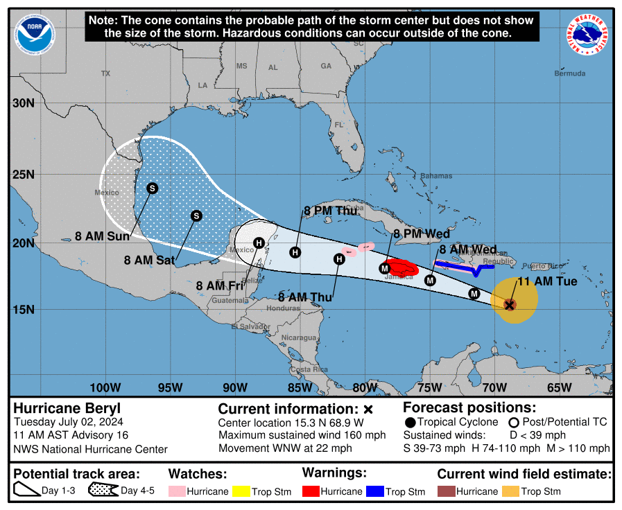
LOCATION…15.3N 68.9W
ABOUT 235 MI…375 KM SE OF ISLA BEATA DOMINICAN REPUBLIC
ABOUT 555 MI…895 KM ESE OF KINGSTON JAMAICA
MAXIMUM SUSTAINED WINDS…160 MPH…260 KM/H
PRESENT MOVEMENT…WNW OR 290 DEGREES AT 22 MPH…35 KM/H
MINIMUM CENTRAL PRESSURE…938 MB…27.70 INCHES
DISCUSSION AND OUTLOOK
———————-

From tropical Iidbits
At 1100 AM AST (1500 UTC), the center of Hurricane Beryl was located near latitude 15.3 North, longitude 68.9 West. Beryl is moving toward the west-northwest near 22 mph (35 km/h), and this general motion should continue through Wednesday, followed by a turn more toward the west on Thursday. On the forecast track, the center of Beryl will move quickly across the central Caribbean Sea today and is forecast to pass near Jamaica on Wednesday and the Cayman Islands on Thursday. The center is forecast to approach the Yucatan Peninsula of Mexico on Thursday night.
Reports from Air Force Reserve and NOAA Hurricane Hunter aircraft
indicate that maximum sustained winds are near 160 mph (260 km/h) with higher gusts. Beryl is a category 5 hurricane on the
Saffir-Simpson Hurricane Wind Scale. Weakening is forecast later
today, but Beryl is still expected to be near major hurricane
intensity as it moves into the central Caribbean and passes near
Jamaica on Wednesday and the Cayman Islands on Thursday. Additional weakening is expected thereafter, though Beryl is forecast to remain a hurricane in the northwestern Caribbean.
Hurricane-force winds extend outward up to 40 miles (65 km) from the center and tropical-storm-force winds extend outward up to 175 miles (280 km).
The latest minimum central pressure estimated from the Hurricane
Hunter aircraft data is 938 mb (27.70 inches).