Hurricane impacts expected in Puerto Rico; dangerous rip current risk along the U.S. East coast
From AccuWeather

On the heels of Debby, confidence is growing that a tropical rainstorm over the central Atlantic could rapidly organize into a tropical storm and later into a powerful hurricane.
AccuWeather Global Weather Center – Aug. 11, 2024 – AccuWeather expert meteorologists are closely monitoring a tropical rainstorm that is forecast to intensify and bring heavy rainfall, gusty winds, and storm surge to parts of the Lesser Antilles, Puerto Rico, and the Dominican Republic this week.
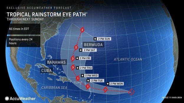
AccuWeather was the first known source to issue a forecast track Saturday evening, alerting the public of a hurricane threat next week. The AccuWeather Eye Path® warns of a Category 1 hurricane on the Saffir-Simpson Hurricane Wind Scale to impact the Lesser Antilles on Tuesday. AccuWeather Lead Hurricane Expert Alex DaSilva expects this tropical threat to strengthen into a Category 3 on the Saffir-Simpson Hurricane Wind Scale by Thursday in the Atlantic Ocean.
“There are growing concerns that a hurricane could threaten the northeastern Caribbean on Tuesday and Wednesday. Very warm sea-surface temperatures and very high ocean heat content, which is the depth that warm waters reach below the surface, are in the path of this tropical rainstorm,” said DaSilva. “Wind shear is forecast to be light as the storm approaches and moves through the islands. All residents of the islands need to watch this storm closely for the potential that it could try to rapidly intensify on its final approach to the islands.”
Ernesto is the next name on the list of Atlantic storm names.
AccuWeather expert meteorologists refer to certain developing tropical threats as tropical rainstorms to raise awareness about the disruptions, damage, and dangers that a system could pose before it becomes a named storm.
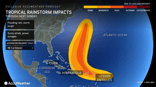
This tropical rainstorm is a 1 on the AccuWeather RealImpact™ Scale for Hurricanes in the Northeastern Caribbean due to the threat of flooding rainfall, damage to homes and trees, localized power outages, and coastal inundation.
Timeline of impacts
AccuWeather is forecasting wind gusts of 40-60 mph and 4-8 inches of rainfall to impact parts of the northeastern Caribbean. Rain and gusty winds are expected to arrive in the Lesser Antilles on Monday. Impacts are expected to reach Puerto Rico on Tuesday.
Parts of the Lesser Antilles could experience 3-6 feet of storm surge. People along the eastern and northern coastlines of Puerto Rico should be prepared for 1-3 feet of storm surge.
DaSilva says families, businesses, and officials in Bermuda and along the East coast of the United States should closely monitor AccuWeather forecast updates for potential impacts later in the week.
“After moving through the islands, the storm is forecast to be pulled to the north by a southward dip in the jet stream. The storm may continue to intensify and could become the second major hurricane of the season by the end of this week. We will keep a close eye on Bermuda next weekend as the storm could make a close pass,” said DaSilva. “If this dip in the jet stream is able to get close to what will likely be Ernesto, then the storm could be pulled west and could impact the Canadian Maritimes. While the chance of direct impacts to the Northeast U.S. appears low at this time, this steering pattern has a lot of factors involved. No one along the East coast should let their guard down.”
DaSilva urges families, businesses, and officials along the East coast of the United States to closely monitor AccuWeather forecast updates and to be prepared for hazards at the beaches.
“This storm could bring rough surf and dangerous rip currents to beaches along the Southeast U.S. Atlantic coast toward the end of this week. The rip current risk will expand north to mid-Atlantic and Northeast beaches by the weekend,” warned DaSilva. “We could see very dangerous rip currents, even though the storm will be hundreds of miles out to sea and the weather may look fine. Anyone heading to East coast beaches this week needs to be aware and know the warning signs. It’s best to stay in areas where lifeguards are on duty.”
Why 2024 is expected to be an “explosive” year for hurricanes
DaSilva said everyone along the U.S. Atlantic and Gulf Coasts, as well as families and businesses well inland, need to be prepared for an “explosive” hurricane season.
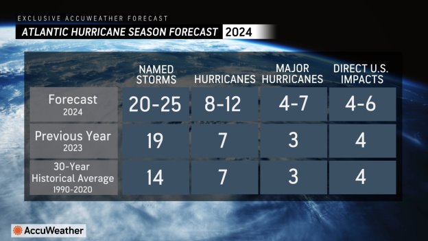
AccuWeather expert meteorologists issued the first Atlantic hurricane season forecast in March, warning of 20-25 named storms and 4-6 direct impacts to the United States.
Very warm water temperatures and favorable weather patterns make it more likely for tropical waves to be able to develop and intensify in the Atlantic basin this season.
“Ocean Heat Content, which is a measure of how far warm water extends down into the ocean, is at near-record levels in the Main Development Region of the Atlantic Ocean, where most storms form. We not only have very warm water temperatures at the surface, we have that warm water extending hundreds and hundreds of feet down below the surface,” explained DaSilva. “These factors can help to significantly contribute to the rapid intensification of hurricanes. Hurricane Beryl took advantage of these incredibly warm waters and rapidly intensified last month, bringing extreme impacts to the Gulf Coast and spinning up tornadoes more than 1,000 miles away from where it made landfall in Texas. Hurricane Ian also took advantage of the very warm waters in 2022. Hurricane Ian rapidly intensified right before landfall, bringing catastrophic and deadly storm surge to Southwest Florida.”
AccuWeather Chief Meteorologist Jon Porter said hurricane impacts are already taking a major financial toll on the United States this year. Porter warns that tropical threats are expected to increase as we approach the peak of the season, which typically starts in mid-to-late August.
“Debby is the second billion-dollar storm to hit the United States this hurricane season,” said Porter. “This hurricane season poses a major economic threat to the U.S. this year.”
Debby blasted the East coast last week with two landfalls, flooding rainfall, storm surge, and beach erosion across the Southeast. Debby then moved through the mid-Atlantic and Northeast, causing devastating flash flooding and producing damaging tornadoes.
AccuWeather experts issued a preliminary estimate of the total damage and economic loss from Hurricane Debby in the United States at $28 billion.
Hurricane Beryl shattered records last month when it became the earliest Category 5 hurricane to form in the Atlantic. Beryl had devastating impacts when it made landfall in the Windward Islands as a major hurricane, and caused more damage when it made a second landfall in the Yucatan Peninsula of Mexico. Beryl eventually made a third landfall in Texas, knocking out power to millions of Texas families and businesses for more than a week. Beryl then became a prolific tornado producer, spinning up dozens of damaging tornadoes as it moved inland from the Gulf Coast all the way to upstate New York.
AccuWeather experts issued a preliminary estimate of the total damage and economic loss from Hurricane Beryl in the United States at $28-32 billion.
“People need to be prepared for more hurricane threats the rest of the summer and fall,” warned Porter.
AccuWeather Forecast Graphics:
Additional AccuWeather Resources:
Tropical rainstorm to intensify as it barrels toward the Caribbean Islands
Hurricane Tracking & Storm Radar
How to avoid the potentially deadly grip of a rip current
Debby’s wrath moves into Northeast with flood emergencies
AccuWeather’s Preliminary Estimate of the Total Damage and Economic Loss from Hurricane Debby in the United States is $28 Billion
AccuWeather Forecasts Explosive 2024 Hurricane Season
Rapidly Intensifying Hurricanes Near Coastline Pose Major Threat To US This Season