Powerful hurricane forecast to bring dangerous rip current risk to US East coast, Caribbean on alert for impacts

AccuWeather expert meteorologists are urging people in the Virgin Islands, Puerto Rico and Hispaniola to prepare for gusty winds, heavy rainfall and a risk of flash flooding this week.
AccuWeather Global Weather Center – Aug. 12, 2024 – A tropical rainstorm moving through the central Atlantic is expected to develop into Tropical Storm Ernesto within the next 24 hours, bringing heavy rain, gusty winds and storm surge to parts of the Caribbean islands.
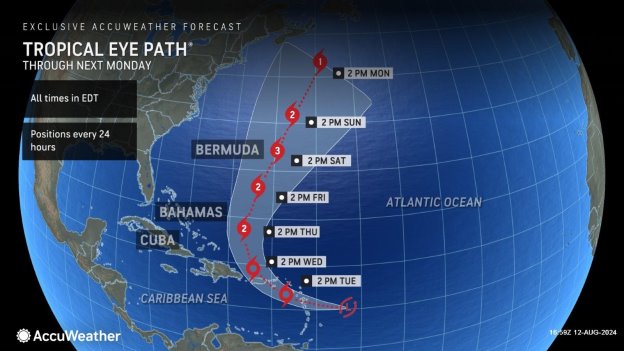
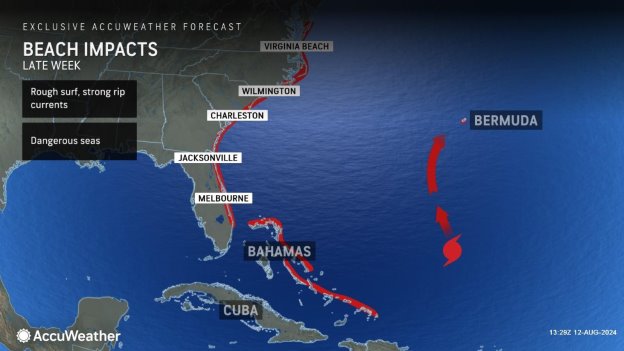
AccuWeather expert meteorologists expect this tropical threat to make a northward turn by the middle of this week and intensify into a powerful hurricane, sending rough surf and a risk of dangerous rip currents to the entire East coast of the United States later this week.
“Rip currents could be very dangerous along the East coast of the United States. We often see rescues and loss of life at beaches during these types of storms,” said AccuWeather Lead Hurricane Expert Alex DaSilva. “The storm may be hundreds of miles out to sea and the weather could look great at beaches along Florida, the Carolinas, even up to New England, but everyone needs to be aware of the risks and dangers at the beach. We expect the rip current risk along the Atlantic coast of the U.S. to start later this week along the Southeast and ramp up over the weekend, expanding to the north. If you’re headed to the beach, please stay in areas where lifeguards are on duty.”
AccuWeather expert meteorologists refer to certain developing tropical threats as tropical rainstorms to raise awareness about the disruptions, damage and dangers that a system could pose before it becomes a named storm.
Timeline of Impacts
AccuWeather expert meteorologists issued the first forecast track for this storm Saturday evening to alert people in the Caribbean about the potential impacts.
DaSilva says very warm water and decreasing amounts of dry air in the path of the tropical rainstorm will be favorable factors for intensification, which may occur rapidly. The only factor that has the potential to hold back the intensification of the storm is moderate amounts of wind shear.
“This tropical rainstorm is encountering some wind shear, much of it is self-imposed. The storm is moving quickly off to the west at 25 mph with maximum sustained winds of 30 mph. The tropical rainstorm is moving almost as fast as the strongest winds in the storm. It’s very impressive,” explained DaSilva. “The average speed of a storm in the Atlantic is around 15 mph. This is going 10 mph faster than that. It’s actually holding itself back from development because it’s moving so fast. We expect this storm to slow down as it approaches the Leeward Islands, so it will encounter less of the self-imposed wind shear.”
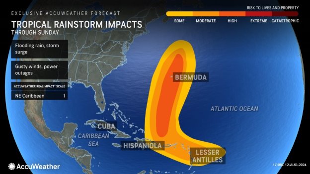
This tropical rainstorm is a 1 on the AccuWeather RealImpact™ Scale for Hurricanes in the northeastern Caribbean due to the threat of flooding rainfall, damage to homes and trees, localized power outages and coastal inundation. Later in the week, a RealImpact™ Scale rating will likely be designated for Bermuda.
Rain reached the Lesser Antilles on Monday. Rainfall will arrive in the Virgin Islands and Puerto Rico later Monday night and Tuesday. As the storm crosses the northern Caribbean, heavy rain is expected which could cause flooding and mudslides, especially across the mountainous terrain of some of the islands.
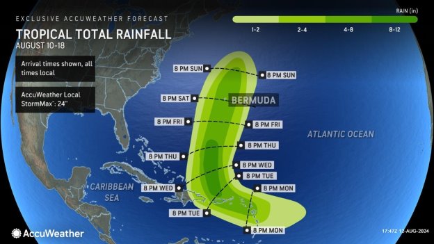
Rainfall totals of 1-2 inches will stretch from the Lesser Antilles through Puerto Rico. Near where the storm tracks, 4-8 inches of rain is expected with an AccuWeather Local StormMax™ of 24 inches, most likely in the highest terrain. This rain could lead to life-threatening flooding and mudslides across the northern and eastern Caribbean.
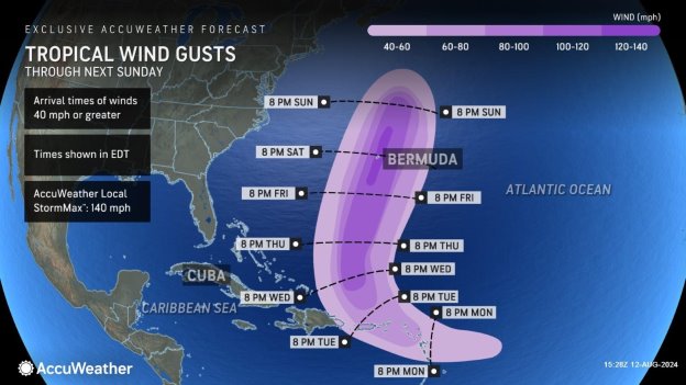
Sustained winds of 40-60 mph will stretch from the Lesser Antilles through Puerto Rico. Wind gusts of 60-80 mph are expected in the northeastern Caribbean, with an AccuWeather Local StormMax™ of 90 mph.
A storm surge of up to 3-6 feet could occur in portions of the Lesser Antilles, which may lead to flooding and coastal erosion through Tuesday. Puerto Rico could also experience 3-6 feet of storm surge along its northern and eastern coastline.

As the storm intensifies later this week, stronger wind gusts of 100-120 mph, with an AccuWeather Local StormMax™ of 140 mph, are expected in Bermuda. These winds can bring down trees and power lines, cause structural damage and could leave areas without power for weeks.
Rain could arrive in Bermuda by next weekend and bring 4-8 inches to the island, which will raise flooding concerns.
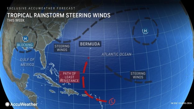
“The Bermuda high is expected to steer this tropical rainstorm to the north and west to the islands. A big dip in the jet stream coming off the East coast can then pull this storm to the north, almost at a 90-degree turn,” said DaSilva. “We expect another dip in the jet stream next week, which could pull the storm back to the west a bit, impacting Nova Scotia or Newfoundland.”
Costly year for hurricane damage
AccuWeather Chief Meteorologist Jon Porter says 2024 is quickly turning into an expensive year for hurricane damage and impacts across the United States. The peak of hurricane season activity typically arrives in mid-to late August.
AccuWeather experts issued a preliminary estimate of the total damage and economic loss from Hurricane Debby in the United States is $28 billion.
Last month, AccuWeather experts issued a preliminary estimate of the total damage and economic loss from Hurricane Beryl in the United States at $28-32 billon.
“Flooding damage is particularly expensive when homes and businesses are inundated. It’s not just the initial cleanup costs and property losses. Mold and mildew can create big issues, and a lot of people are underinsured for flooding,” said Porter. “Most homeowners insurance policies do not cover flood damage. People in inland areas tend to have less flood insurance coverage.”
Porter says AccuWeather’s preliminary estimate of the total damage and economic loss from Hurricane Debby includes the widespread impacts to the tourism and travel industries along the East coast.
“Debby hit during a terrible time for vacation and tourism businesses,” said Porter. “Many small businesses depend on this time of year to make their profit margin for the entire year. A lot of families cut their vacations short or didn’t show up at all because of this storm. That economic hit is being felt far and wide along the path followed, from the Southeast, through the mid-Atlantic and up to the Northeast.”
Porter says families, businesses and officials need to be prepared for the likelihood of more tropical threats in the coming weeks.
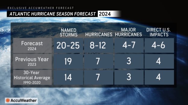
The AccuWeather 2024 U.S. Hurricane Forecast predicts 20-25 named storms in the Atlantic basin and four to six direct impacts to the U.S. this year.
AccuWeather Forecast Graphics:
Additional AccuWeather Resources:
Tropical rainstorm to intensify as it barrels toward the Caribbean Islands
Hurricane Tracking & Storm Radar
How to avoid the potentially deadly grip of a rip current
Debby’s wrath moves into Northeast with flood emergencies
AccuWeather’s Preliminary Estimate of the Total Damage and Economic Loss from Hurricane Debby in the United States is $28 Billion
AccuWeather Forecasts Explosive 2024 Hurricane Season
Rapidly Intensifying Hurricanes Near Coastline Pose Major Threat To US This Season
“