Tropical Storm Matthew forms in the Lesser Antilles Islands
 By: Jeff Masters From Weather Underground
Tropical Storm Warnings are flying in the Lesser Antilles Islands thanks to newly-formed Tropical Storm Matthew. An Air Force hurricane hunter aircraft found on Wednesday morning that Invest 97L had finally developed a closed circulation, and had surface winds near 60 mph in a powerful cluster of thunderstorms that was located about 50 miles east of Martinique at 9:22 am EDT. These strong winds will move over the islands of Martinique and Dominica early this afternoon, given Matthew’s westerly motion at 20 mph. At 11 am EDT, Dominica reported sustained winds of 33 mph, gusting to 53 mph, and Martinique reported sustained winds of 28 mph, gusting to 40 mph. Radar imagery out of Martinique and Barbados on Wednesday morning showed plenty of rotation to the storm’s echoes, and an increase in their intensity and areal coverage. Satellite loops showed that Matthew was developing a well-defined surface circulation, and had an increasing amount of heavy thunderstorm activity that was growing more organized. Aiding development was moderate wind shear of 10 – 20 knots and warm ocean waters of  29.5°C (85°F). The 8 am EDT Tuesday SHIPS model output analyzed 50 – 55% relative humidity at mid-levels of the atmosphere over Matthew, which is lower than optimal for tropical cyclone formation, and water vapor satellite loops showed Matthew was butting into a region of dry air that lay just west of the Lesser Antilles Islands. Lack of spin from being too close to the equator was less of a problem for Matthew than before, as the system had worked its way northwards to a latitude of 13°N. This is far enough from the equator for the storm to be able to leverage the Earth’s spin and acquire more spin of its own.
Figure 1. Barbados radar at 10:20 am EDT September 28, 2016 showed a large region of heavy rains from Matthew beginning to move into the Lesser Antilles Islands. The Hurricane Hunters found surface winds of 60 mph under the cell just east of Martinique. An “X” marks the center of Matthew. Image credit: Barbados Met Service.
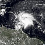
Figure 2. Latest satellite image of Matthew.
Two-day forecast for Matthew
Matthew will average a westerly motion at about 15 mph through Thursday morning. The core of the storm will pass through the Lesser Antilles Islands on Wednesday afternoon, with the storm’s strongest winds and heaviest rains of 4 – 8” affecting the islands just
north of the center, including St. Lucia, Martinique, Dominica, and Guadaloupe. The storm will continue westwards on Thursday, and make its closest approach to the ABC islands of the Netherlands Antilles—Aruba, Bonaire, and Curacao—on Thursday night and Friday morning. These islands will be on the weak (left) side of the storm, and will likely escape receiving tropical storm winds, though rains of 1 – 2” can be expected. As Matthew passes through the southeastern Caribbean, it will be in an environment somewhat unfavorable for development. Tropical cyclones passing near the coast of South America often suck in dry continental air from the land areas to the south, and the latest SHIPS model forecast predicts that Matthew will have to contend with moderate wind shear and dry air through Friday. The last hurricane to pass through the southeastern Caribbean, Hurricane Tomas of 2010, degraded from a Category 1 hurricane to a tropical depression due to high wind shear and dry air as it moved across the region. Expect only slow intensification of Matthew on Thursday and Friday.
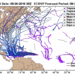
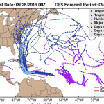
Figure 3. Forecasts from the 00Z Wednesday European (ECMWF) model ensemble (top) and GFS model ensemble (bottom) had a number of their 70 members predicting a hurricane for late in the week in the Caribbean (light blue dots.) The operational versions of the models, run at higher resolution (red lines), also showed the storm becoming a hurricane by four days into the future. The two models have grown closer together in their solutions compared to Tuesday, but the European model still shows a considerably slower and more westerly track for Matthew than the GFS model.
Longer-range forecast for Matthew
Matthew is being steered by a ridge of high pressure that extends only as far west as the ABC islands. Matthew will slow down to a forward speed of 5 – 10 mph by Friday as it reaches the edge of this ridge, and the storm will maintain that slow forward speed though the weekend. A large upper-level low pressure system has separated from the jet stream and will settle over east-central U.S. late this week, and the steering currents associated with this low are expected to be strong enough to pull Matthew sharply to the north by the weekend, according to the Wednesday morning runs of the models. This sharp turn is expected to occur on Friday night or on Saturday, and the exact timing of the turn has huge implications for who experiences the peak wrath of the storm. An earlier turn is being predicted by the GFS model, with a landfall by the storm in eastern Cuba on Monday morning. Matthew is then predicted to move through the central Bahamas on Tuesday. The European model forecasts a later turn, with a landfall in Jamaica on Monday night, and then in eastern Cuba on Tuesday night. The 00Z Wednesday run of the UKMET model brings Matthew northward across Haiti on Monday and into the southeastern Bahamas by Tuesday. As one can see from the latest set of ensemble model runs (Figure 3), the long-range uncertainties in Matthew’s long-range track are high. Now that Matthew has finally established a coherent center of circulation, expect the forecast uncertainty to improve in this evening’s model runs. Matthew is expected to have favorable conditions for intensification this weekend as it heads north, with low wind shear, very warm ocean waters, and a very moist atmosphere. The models are quite bullish on this storm being a hurricane when it makes its landfall early next week in the islands, and residents of Jamaica, Haiti, and eastern Cuba should anticipate the possibility of a hurricane affecting them early next week.
For more on this story go to: https://www.wunderground.com/blog/JeffMasters/comment.html?entrynum=3448


