We’ve never seen an East Coast winter storm intensify as fast as the ‘bomb cyclone’
 BY ANDREW FREEDMAN From Mashable
The “bomb cyclone” that slammed the East Coast on Wednesday and Thursday exceeded weather forecasters’ expectations in nearly every way. It dumped more than a foot of snow on the Mid-Atlantic and Northeast, including 16 inches in Islip, Long Island, and flooded parts of downtown Boston with a storm surge that sent water rising to historic levels.
The storm got its name for the process known as bombogenesis, which describes a storm whose minimum central air pressure plummets by at least 24 millibars in 24 hours.
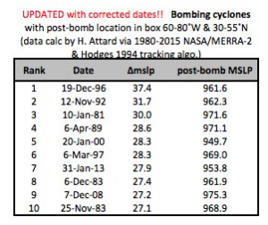
On Thursday, the bomb cyclone intensified by 59 millibars in 24 hours, which is the fastest rate ever observed in any other winter storm along the East Coast since at least 1976, according to data from David Roth, a meteorologist at the Weather Prediction Center, and Andrea Lang, an assistant professor at the University of Albany.
Andrea Lopez Lang
@alopezlang
List of the 10 ten strongest East Coast #bombCyclone s in the 1980-2015 MERRA-2 data. Thanks to @HannahAttard for creating the full list. Only includes bombs with locations of deepening 24 hPa in 24 hr ending in a box 60-80˚W & 30˚-55˚N pic.twitter.com/23paZ3zPZW
Andrea Lopez Lang
UPDATED!!! Dates corrected
Lang said that research by her and Hannah Attard, a doctoral student in her research group, found 1,218 cyclones that originated north of 30 degrees North latitude and met the bombogenesis criteria in the Northern Hemisphere between 1980 and 2015. This indicates that meteorological bombs, so to speak, aren’t that rare.
“What is uncommon is the rate of deepening for the 4 January cyclone,” Lang said in an email. “If you filter all 1218 cyclones that meet the ‘bomb’ criteria for those that occurred in a box just off the East Coast (60-80˚W and 30-55˚N) we find 23 ‘bomb’ cyclones in the 1980-2015 reanalysis data.”
“This storm would be the new number 1 in terms of 24 hr mean sea level pressure fall… for storms on our list,” she added.
Marshall Shepherd
@DrShepherd2013
Synoptic meteorology h/t @VORTEXJeff
The intensification rate isn’t just a bit of trivia for weather geeks, either. It had implications for the storm’s impacts, primarily by accelerating the storm’s winds. Winds gusted to hurricane force, or 75 miles per hour, across Cape Cod and the Islands, and high winds raked everywhere from the Carolinas to Nova Scotia.
This occurred because air was rushing in toward the center of the storm in response to the rapid drop in air pressure. Such winds helped drive the storm surge flooding that created so many problems in New England, too.
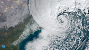
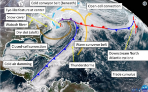
The satellite imagery taken of the storm clearly shows how intense it became, as it even sported an eye-like feature near its center. Meteorologist Jeff Frame annotated an image to show all the meteorological features it revealed.
NOAA Satellites
@NOAASatellites
#GOES East captured the full path of the #BombCyclone exhibiting a rare and extremely rapid rate of intensification on the East Coast with some of the coldest wind chills of the season and near zero visibility in the snow bands @NWS. #Blizzard2018 More: http://goo.gl/eEwncX
There are many reasons why this storm intensified so quickly and significantly, with a minimum pressure eventually dropping to levels more typically seen in Category 2 or 3 hurricanes. For one, there were tremendous contrasts in air masses between cold, dry Arctic air pouring in from the northwest, and moisture-rich subtropical air streaming north over the Atlantic.
“There are several factors that contribute to the intensification of all cyclones, all of these factors were on the extreme side for this event,” Lang said.
“All extratropical cyclones, which includes storms like nor’easters, form on boundaries between cold and warm air. However, not all nor’easters form when there is record-breaking cold air already in place along the east coast,” she said. “In general terms, the magnitude and scale of the temperature contrast is an indicator of energy available for cyclone intensification.”
Lang said that the southern location of the initial storm, which spun up near the coast of Florida, added more energy to the mix.
“The fact that the cyclone formed as far south as it did allowed the cyclone [to maintain] a link to the subtropics (nicely shown in the satellite imagery),” she said.
“The subtropical link provided the cyclone with a source of fuel, in the form of water vapor, that fed the large field of precipitation and enhanced the storm strength.”
While many of the East Coast’s most memorable snowstorms also underwent bombogenesis, there was nothing typical about this particular weather bomb. And that’s why satellite images of it have been saved to weather geek’s hard drives, (and set as my new desktop background.)
This storm was a beast, and looked absolutely gorgeous from space.
IMAGES:
Image of the ‘bomb cyclone’ from the new GOES-16 satellite, taken on Jan. 4, 2018.IMAGE: NASA
Zoomed-in satellite image of the eye-like feature in the ‘bomb cyclone’ on Jan. 4, 2018.
IMAGE: NOAA
For more on this story go to: http://mashable.com/2018/01/05/bomb-cyclone-satellite-images-record-intensification-rate/?utm_source=feedburner&utm_medium=feed&utm_campaign=Feed%3A+Mashable+%28Mashable%29#4txjccekASqh


